Wow, feel like I should be on SO WWW?
OK, much LDPCSD boundary expansion anticipated around the STURTEVANT RANCH/GRANITE SPRINGS AREA – if my green marks on the section map are any indication. Why that far outside the MIDPOU for MERCED RIVER WATER service? The STURTEVANT RANCH AGREEMENT makes sense with the respect to the 10 meters and future water use, although I believe it was limited as to a particular area, and I don’t have time to research that right now, but the point is of the agreement possibly influencing those boundaries makes sense on one level, but on another level it does not.
IF TEN METERS WERE PROVIDED FOR FUTURE WATER USE, THE NUMBER IS KNOWN, A PROBABLE USE DETERMINED. 10 SERVICE CONNECTIONS WHICH HELPS IN CALCULATING ANTICIPATED DEMAND FOR THE FUTURE (assuming traditional uses of water) but allowing anyone who subsequently purchases land from that ranch and is CLEARLY NOT ENTITLED TO A METER, IS REFUSED WATER FROM THE DISTRICT, BUT STILL SOMEHOW OBTAINS A WATER METER THAT IS CHARGED TO SOMEONE ELSE (SOME RECORDS ARE MISSING/DESTROYED REGARDING THIS SERVICE) AND IS PERMITTED TO START A COMMERCIAL CATTLE RANCHING BUSINESS is a bit difficult to understand. So anyway, there are very large parcels of land up there to the northeast and west of the residential subdivision that could multiply with future subdivisions bringing much higher water demands all based on, and INSURED BY, the property owners of the LDPOA and their GROUNDWATER SUBSTITUTION PROGRAM COMPLIMENTS OF KAMPA & KOMPANY.
ANYWAY, MAPS PRODUCED BY KAMPA
-
KAMPA’S “Exhibit B” LDPCSD OFFICIAL BOUNDARY MAP
The handwritten “15” was on the copy contained in the agenda packet. I am unaware of the original material from which this map was removed but it sure looks to be a modified version of a 2008 LAFCo Map. Since customers were once again required to hand number their own agenda packets, this map actually appeared on page 52 of the September agenda packet.
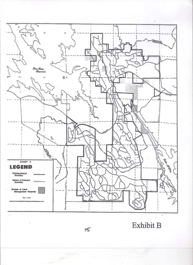
(ABOVE) KAMPA “EXHIBIT B” SERVICE BOUNDARIES ON SEPT 19 2016
(BELOW) 2008 LAFCo MAP. Modified copy of above? Who knows which one was the first, but there are “unrelated blemishes” copied to both maps. Also notice that although the LAFCo Map (bottom) is clearly labeled “Exhibit C” in the bottom right corner, it is also labeled in the title block to the left as “Exhibit B” in small print above the word LEGEND. I don’t know about you folks, but these maps sure as hell don’t look authentic to me – at least not produced by a professional engineer who surveyed the area.
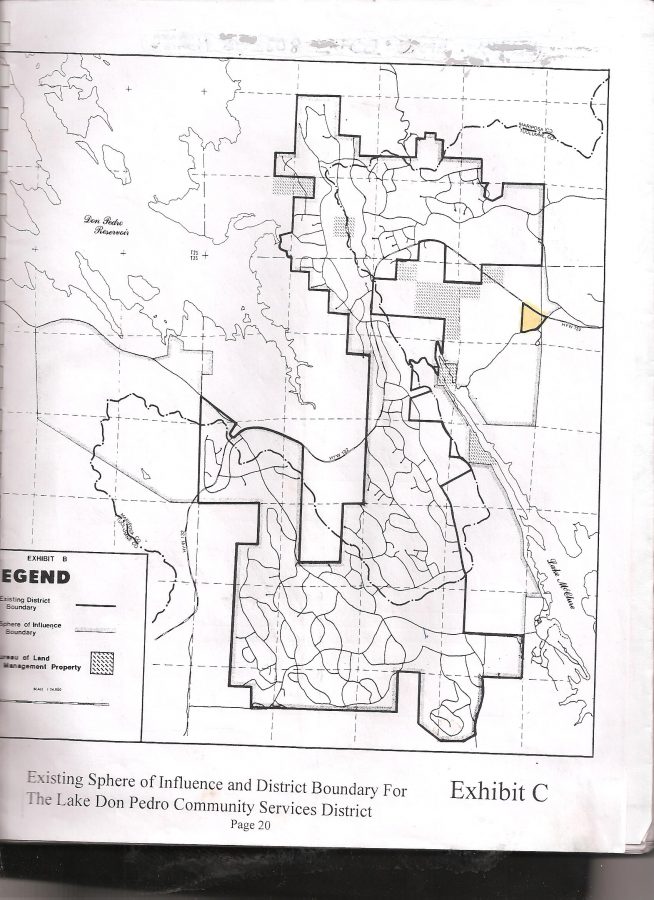
LAFCo 2008 Draft Sewer MSR page 20 of 57 “Exhibit C”
Now on the above LAFCo Map I must take responsibility for the yellow colored PINEY CREEK ISLAND OF SERVICE (something LAFCos are supposed to avoid – islands of services). Years ago I marked that as a curiosity in my beginning journey in understanding our LDPCSD Boundary matters (wonder when that trip will end?). Later I realized in addition to being an island of water service, it was also a good example of election Gerrymandering because that area does not receive LDPCSD water, pays no fees, but is supposedly in our district so individuals living in that mobile home park (and else where) can vote in our elections.
Considering our elections are sometimes settled by a very close margin (a few votes) this is a VERY BIG ISSUE THAT NEEDS INVESTIGATION AS WELL.
How can individuals NOT VESTED IN THE DISTRICT possibly BE ALLOWED to determine who will or will not serve on the BOARD OF DIRECTORS?
Real sketchy information about that whole thing, but I do know such information is used in Sacramento by the State Board of Equalization (among other Boards, Departments, Agencies, Offices for various purposes) to establish the local TAX RATE AREA (TRA). If it is still the same, LAKE DON PEDRO has many more TRAs than most, if not all, parts of Mariposa County. There’s a blog posting on this site somewhere about that issue. Anyway, I colored Piney Creek with a highlighter and ANY INVESTIGATION SHOULD TAKE A LOOK AT HOW TRAs figure into the fraud against the property owners of the LDPOA subdivision by the LDPCSD – for decades!2.
2. KAMPA’S POSTED “SPHERE OF INFLUENCE” MAP ON THE LDPCSD WEBSITE
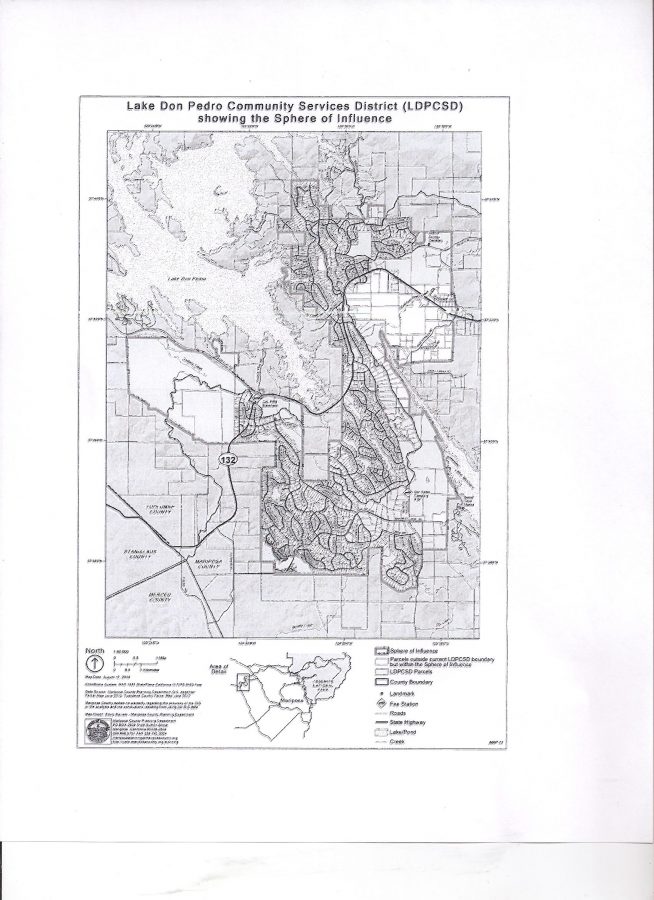
Not a bad looking map and in all likelihood obtained from MARIPOSA COUNTY LAFCo RESOLUTION 2014-16 which updated LDPCSD Maps for their records.
(BELOW) Here’s what the LAFCo LDPCSD SOI (Sphere of Influence) MAP looked like attached to LAFCo RESOLUTION 2014-15:
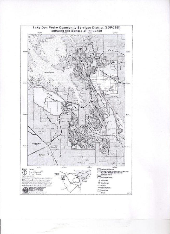
LAFCo page 4 LDPCSD SOI Map
OK, the two maps appear to be the same, but wait a minute, something’s wrong here. Check out where this SOI Map KAMPA used for the website came from – the LAFCo Resolution which contained two maps – not just the SOI! This is where I get very upset and wonder how far LDPCSD corruption actually extends.
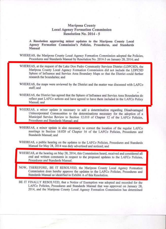
THIS WAS DONE WHILE I WAS STILL ON THE BOARD AND I REMEMBER BECAUSE I WAS TOLD BY THE PRESIDENT OF THE BOARD AND GM THAT I COULD NOT ATTEND BECAUSE DIRECTOR EMERY ROSS WAS GOING! HELL, I EVEN HAD A RIDE WITH ONE OF THE COMMISSIONERS AT THE TIME!
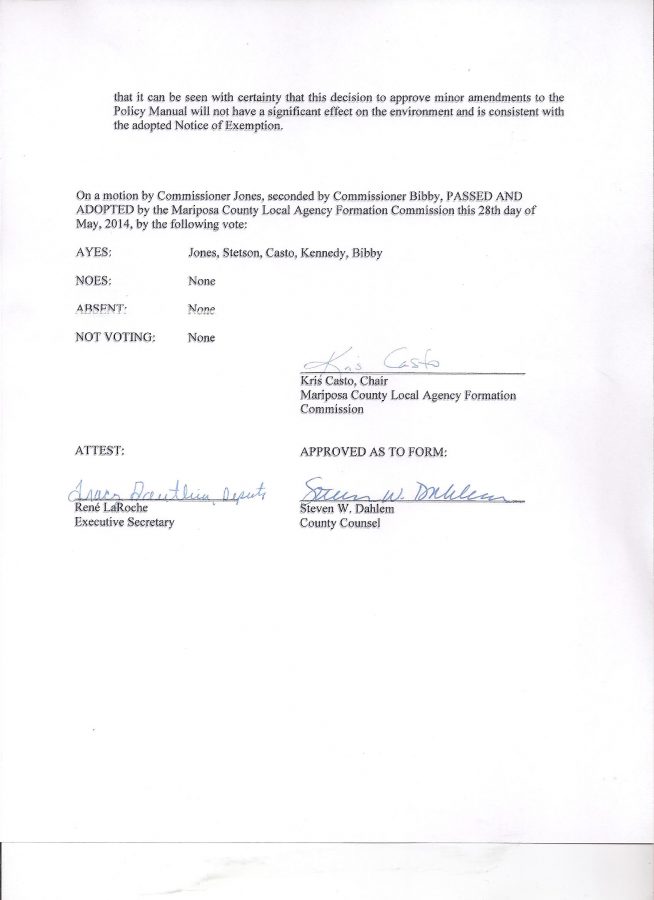
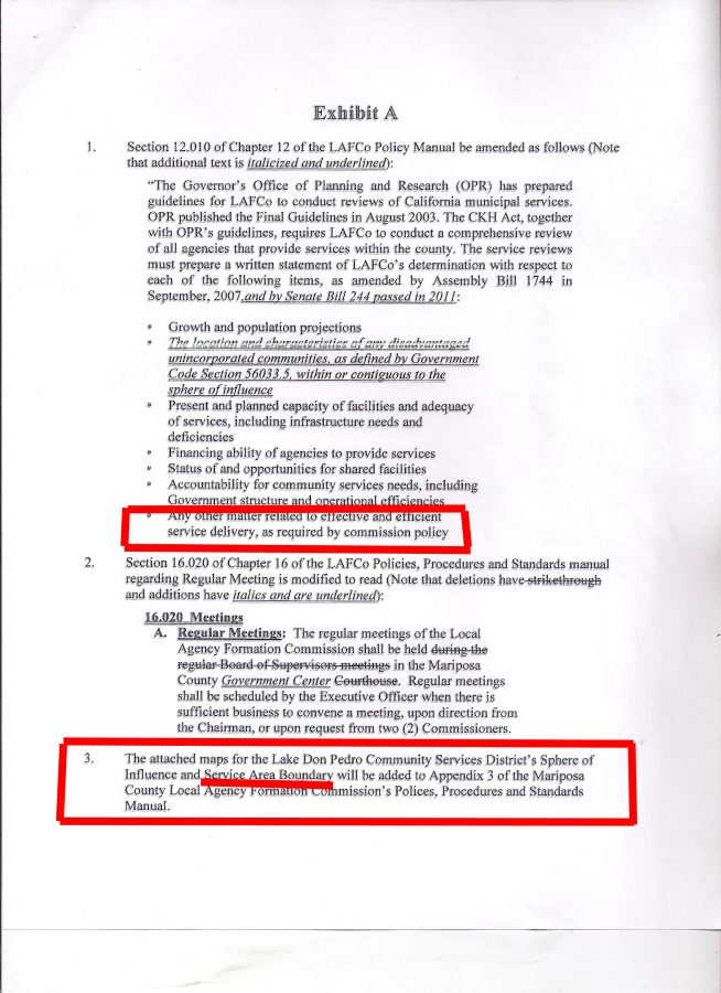
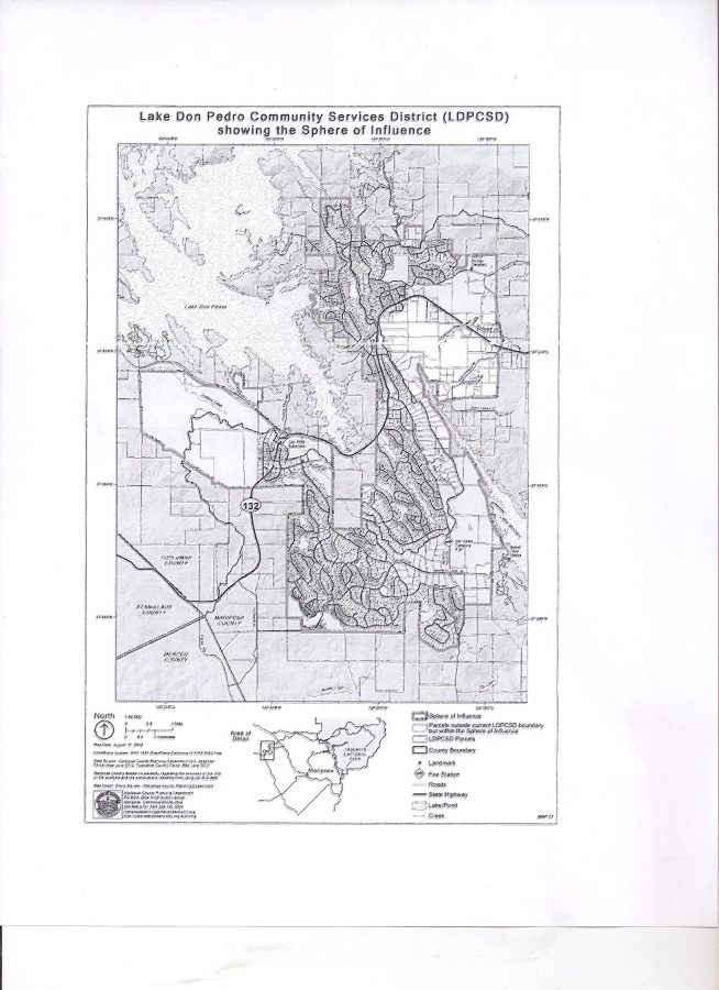
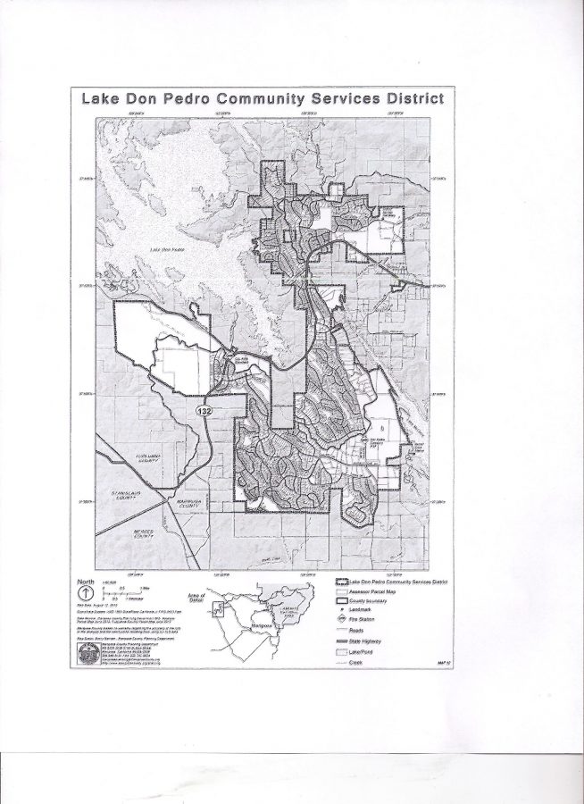
DO YOU SEE IT? THE DIFFERENCE OF PROPERTY WITHIN THE BOUNDARY?
BOTTOM RIGHT QUADRANT?
NOW I FINALLY UNDERSTAND WHY KAMPA HAS BEEN AVOIDING
THE MAP ISSUE FOR SO LONG!
WHY HE OFFERED THE “EXHIBIT B” MAP BELOW
AS THE OFFICIAL LDPCSD SERVICE BOUNDARY!

KAMPA & KOMPANY “EXHIBIT B” OF OFFICIAL LDPCSD SERVICE BOUNDARIES ON SEPT 19 2016
INSTEAD OF THE OTHER LAFCo MAP BELOW!
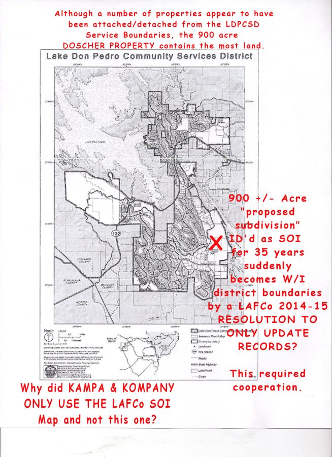
NOW IT GETS INTERESTING
Check out the above documents. I am mad as hell because the way I see it there are few ways for something like this to occur. Unfortunately the most probable orbit around REPRESENTATIVES OF THE LDPCSD INTENTIONALLY PROVIDING FALSE INFORMATION TO MARIPOSA COUNTY PLANNING AND LAFCo WHO THEN WITH A “WINK AND A NOD” ACQUIESCED BY ACCEPTING AND PLACING THIS ABSOLUTE FABRICATION OF THE TRUTH IN OFFICIAL LAFCo FILES. (SURE HOPE THE COUNTY TAKES BETTER CARE OF OFFICIAL RECORDS THAN THE LDPCSD.)
AT THIS POINT I REALLY DO NOT KNOW WHO TO TRUST,
SO AS ALWAYS, I LEFT THAT ISSUE WITH YOU – THE PUBLIC VIEWERS.
I BELIEVE THERE IS SOMETHING HORRIBLY WRONG HERE THAT TRANSCENDS JUST A DEVIOUSLY CREATED AND CORRUPTED COMMUNITY SERVICES DISTRICT. IT IS THE WHOLE “DO WHAT EVER IS NECESSARY ENVIRONMENT” THAT IS CONSUMING OUR ENTIRE COUNTRY. “YEAH, THAT’S REAL BAD BUT……” “NOT MY JOB” “I DON’T CARE WHAT THEY DO” “SO LONG AS I DRAW A PAYCHECK/STIPEND” “WHY SHOULD I RISK MY FAMILY’S SECURITY TO LOCK HORNS WITH THE MOVERS AND SHAKERS OF THIS AREA?” “WHO WILL EVER FIND OUT?” “WHAT’S THE WORST THEY COULD DO?” “JUST SAY IT WAS A SIMPLE MISTAKE”……oh what a tangled web we weave
SO MANY GOOD HONEST PUBLIC OFFICIALS GET TAINTED WITH, CAUGHT UP, OR PULLED INTO, SUCH OBVIOUS CIRCUMVENTION OF, NOT ONLY ESTABLISHED RULES AND REGULATIONS THAT MAY BE INCONVENIENT AND OBSTRUCT DESIRED PROGRESS, BUT THE METICULOUS AVOIDANCE OF SOMETHING FAR MORE IMPORTANT – THE TRUTH!
EVERYONE IS HARMED, INDIVIDUALS, COMPANIES, COMMUNITIES, AND EVERY GOVERNMENT AGENCY AND/OR EMPLOYEE INVOLVED IN SUCH APPARENT FRAUD WHO TURNS THEIR HEAD AND IGNORES WHAT THEY KNOW TO BE WRONG – MINIMIZES THEIR OWN REPUTATION AS WELL, BE IT PROFESSIONAL, INDIVIDUAL, SPIRITUAL, WHATEVER – WHERE IS THE BASIC CONCEPT OF CONSCIENCE AND SHAME?
There’s a lot more to this but I’m pooped.
My best to you and yours, Lew
——and may those involved with this continuing fraud against their neighbors ultimately receive exactly what they have earned.


