Following the LAFCOs (Local Agency Formation Commissions) creation of the LDPCSD in August of 1980, many “annexation resolutions” were drafted and sent to the respective county LAFCOs in Mariposa and Tuolumne County requesting that properties OUTSIDE the residential subdivision (which was and is the legal PLACE OF USE (POU) for Merced River water per water license 11395), be annexed, or brought into, the LDPCSD water service boundary.
Perhaps some of these outside POU properties were indeed annexed into the LDPCSD water service boundary, however, that inclusion into an expanded boundary of service created by LAFCos DID NOT CHANGE THE LEGAL POU FOR MERCED RIVER WATER UNDER THE WATER LICENSE ESTABLISHED UNDER THE AUTHORITY OF THE STATE WATER BOARD.
LAFCo created the LDPCSD fully aware of the restrictions outlined by the CPUC (California Public Utilities Commission) in its Jan 1981 approval of the transfer of Sierra Highlands Water Company’s facilities and assets to the new LDPCSD, however, had apparently already secretly expanded that service area beyond what the CPUC determined and approved as the LEGAL SERVICE AREA for the new LAFCO formed LDPCSD.
WHERE IS THE ORIGINAL LDPCSD SERVICE AREA MAP
WHY HAS IT NOT BEEN REPRODUCED FROM THE EXISTING SURVEY AFTER NEARLY 40 YEARS OF ABSENCE?
A major issue regarding this service area expansion beyond the license POU, is that the ORIGINAL LDPCSD SERVICE AREA MAP PRODUCED FROM A DETAILED METES and BOUNDS FIELD SURVEY COMMISSIONED BY THE MARIPOSA COUNTY LAFCO (11 page survey still exists) has never been provided to those requesting that initially established service area. Thus the LDPCSD began providing water service anywhere it desired without the traditional guidance provided in a service area map.
The Mariposa County LAFCo decision to expand this service boundary was apparently based on the close interaction and prodding by Sierra Highlands officials and their engineers that clearly advocated the continued expansion outside the subdivision and golf course area of permitted service. Sierra engineers and its general manager ultimately assumed those positions with the new LDPCSD and continued the expansion of water service far beyond the water license POU.
Those original SIERRA HIGHLANDS ENGINEERS remained with the LDPCSD until the year 2018 when BINKLEY ENGINEERING ASSOCIATES (formerly Cascade Engineering) noticed they would withdraw as the district’s engineering firm. Those pro-expansion engineers maintained the system for decades while simultaneously designing and promoting further expansion opportunities for the treatment plant and infrastructure.
Please notice the major influence BINKLEY had on determining and expanding the LDPCSD’s SPHERE OF INFLUENCE (SOI) which is only a fancy way of saying “where water service is likely to be provided in the future”.
PLEASE CHECK OUT THE FOLLOWING SOI REPORT AND RECOMMENDATIONS WHICH FOLLOWED A LOGICAL PROPOSAL BY MARIPOSA COUNTY PLANNING THAT THE LDPCSD BE DESIGNATED A ZERO SOI DUE TO THE WATER RIGHTS RESTRICTIONS. THIS SOLIDIFIED THE PRO-EXPANSION EFFORT PRODUCING THE SOI PLAN.
[NOTE: The below 1987 SOI REPORT FOR LDPCSD can be navigated by using the controls at the bottom left corner of the document.]
SERIOUSLY NOW, all political bias aside, does it make sense to you how such a detailed report regarding potential future development of this area dependent upon water, with all the research and fancy sounding concerns about doing things correctly,
NOT ONCE
MENTIONED WATER LICENSE 11395 WHICH QUITE CLEARLY ESTABLISHED WHERE MERCED RIVER WATER COULD BE SERVED IN THIS AREA?
From the beginning of the treatment plant construction in the late 1960s until only a few years after PETE KAMPA and his supporting board of directors began reconfiguration of the surface water treatment plant into a GROUNDWATER SUBSTITUTION FACILITY for speculative land developers outside the subdivision POU for Merced River water per WL11395, the engineers advocated expansion – and the Board of Directors assisted in concealing this agenda from the
MR WECs of the Lake Don Pedro subdivision.
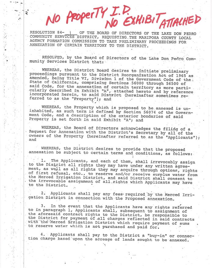
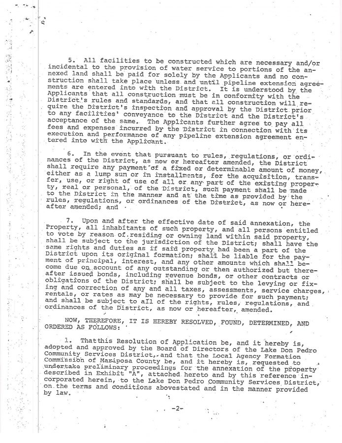
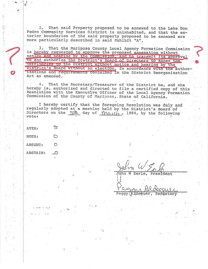
PLEASE NOTE in 84-1 the typical LDPCSD failure to even identify the property that is proposed to be annexed on the face of the resolution along with the very peculiar request (which resurfaces during other questionable attempts at annexation into the district during Kampa’s first employment tour) that the whole process remain secret and concealed from the legal customers of the LDPCSD and public.
Also missing from many of these annexation resolutions is the stated “exhibit attached” notation when there is no exhibit attached.
The annexation process utilized by the LDPCSD is reminiscent of the original “automobile assembly line” where parts of the final product were interchangeable with all other final productions, didn’t matter, as they were all essentially the same:
no property identification, no “attached exhibit”, concealed from the paying legal customers, and intentionally and completely violated state law regarding water license rights and restrictions contained in WL11395.


