So many peculiar coincidences seem to orbit around the LAKE DON PEDRO COMMUNITY SERVICES DISTRICT.
Well, wait a sec… not coincidences exactly, although the LDPCSD has certainly exhibited many of those through the years, but more like small but extremely powerful vacuums, or …. black holes. Yes that’s it, black holes.
You know, like in the universe where the black hole gravity is so strong not even light can escape. A singularity where only a thin ring of light is observable as everything is sucked into the black hole darkness. Yeah, black holes, that’s more accurate and descriptive. Little “black holes” that constantly orbit around the LDPCSD environment and protect sensitive issues. Black holes that crisscross back and forth monitoring and searching for any semblance of complaint or question regarding the decades of unethical activity our public agency has pursued on behalf of speculative land developers not entitled to MERCED RIVER WATER service as is the Lake Don Pedro subdivision.
And when these black holes encounter such questions and/or complaints?
Whoosh!
All neatly vanish into a dark unknowing realm, out of sight, ignored and eventually forgotten until the next time the process is repeated again, and again, and again but always to the same inevitable conclusion—–
no answers to legitimate questions while institutionalized fraud continues unchecked.
However, differing from the traditional concept of a black hole in space which consumes everything including light, the
LDPCSD Black Holes devour anything that might shed light – on the truth!
The “powers that be” certainly do not want the <MR WECs> of the subdivision to understand their designed and critical roles as perpetual financial victims.
RECALL my last attempt to escape these “defensive truth gravity wells” to obtain some legitimate assistance?
Here’s that old post below – just “click” the title for the whole enchilada (sounds good about now huh?).
SURE I CAN WAIT. YOU CAN WAIT. WE CAN ALL WAIT. MR WECs OF THE LDP SUBDIVISION WAITED 37 YEARS!
REASON FOR THIS STROLL DOWN MEMORY LANE AND Blah blah blah
ABOUT TRUTH SUPPRESSING MUTANT BLACK HOLES?
Anyone care to take a wild guess as to what happened to that detailed complaint sent to the Sheriff’s Office on June 30th, 2017 (and later publicly posted on this website on July 3rd, 2017 when no acknowledgement of receipt had been received yet)?
If your reply was “A BLACK HOLE ATE IT“, you might be correct.
____________
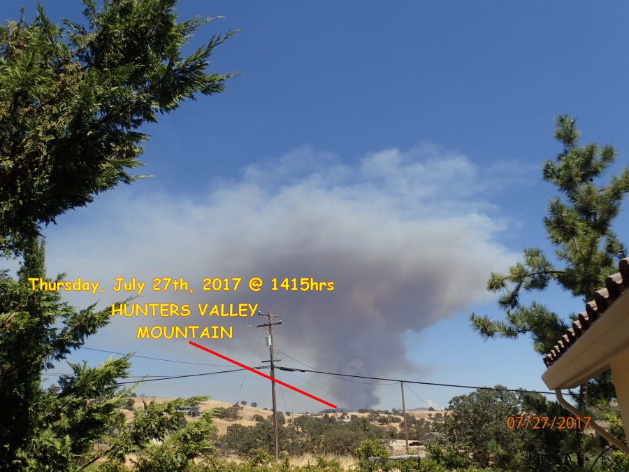
Regardless, I waited for the semi- conclusion of the Detwiler Fire Emergency to check on the status of the complaint, but was advised on Tuesday, August 1, 2017 by a Mariposa County Sheriff’s sergeant that the individual responsible for communications through “sheriff@mariposacounty.org” stated the material was never received. Would I resend it?
I asked if his statement was a joke – confirming it was not – you bet I’ll resend it!
Strange, I was never notified through my email service that the communication was undelivered (like when you mistype the address or the destination no longer exists). I wonder what sort of E-communication tracking is available for such a law enforcement/county government email address? I would suspicion there is a record of everything sent and received through that address somewhere – considering the potential for extremely important information being relayed. How often does information sent to that address get lost somehow? How would they know if there was no follow up by the sender? How could government officials confirm and reassure the public that critically important information sent to this address was not being lost or “hi-jacked” from delivery to the intended recipient? I would be very surprised and disappointed if there were not some sort of electronic accountability for such government communications in this day and age of technology.
wow – how deep is this rabbit hole?
SAVED A FEW DOLLARS THIS TIME
Well at least I did not have to hand deliver it like the information request to the Merced Irrigation District that was somehow lost between Sacramento and Merced. Imagine, a USPS certified letter with a request for information regarding the MERCED RIVER WATER COMPLIANCE REPORTING the LDPCSD has done for 17 years mysteriously lost with no explanation. (Stranger still is the fact that Pete Kampa with all his LDPCSD experience wasn’t aware of such reporting requirements? Sorry, highly implausible.) Then later, after receipt of the “walk-in request” for the information the MID still wasn’t sure what I was requesting. 17 years of reporting and no clue as to what I was requesting? Stranger still, eh?
OK – I’LL RESEND TO THE MARIPOSA CO SHERIFF’S OFFICE w/BONUS
I resent the five pages of material outlining my fraud complaint (same address as before: sheriff@mariposacounty.org) and this time received confirmation it was received. Considering the circumstances I decided it might be prudent to forward the original complaint to the Mariposa County District Attorney’s office as well. They acknowledged receipt!
There are curious aspects as to the complaint not being received by the sheriff’s office along with confusing subsequent statements as to the complaint’s prior investigation, determinations made, by whom, and the current complaint status which I am anxious to follow up on. However, in all fairness to the district attorney (now involved with the forwarding of material), I believe withholding my traditional up to the moment emotional blah blah blahs for a while might also be prudent, if for no other reason than simple courtesy and respect for the District Attorney.
We shall see.
My best to you and yours, Lew
![]()