HOW CAN ANYONE BELIEVE THESE ARE TRUTHFUL RESPONSES TO EXTREMELY SERIOUS QUESTIONS?

Absolutely amazing (AND FRIGHTENING) how successful the CLINTON MACHINE is at concealing pertinent information – aka THE TRUTH!

Unbelievable how such information is only coming out so close to the November election.

I just read this and thought I would pass it on as relevant to our situation:

(check out the below link)

HILLARY CLINTON CANNOT RECALL EXTREMELY IMPORTANT FACTS AS TO WHY SHE HAD AND USED A PRIVATE SERVER?

Oh please!  I think most “thinking people” can appreciate this INTENTIONALLY CONFUSED ISSUE as simply:

THE ONLY EXPLANATION FOR HAVING A PRIVATE SERVER

IS TO KEEP INFORMATION ON THAT SERVER PRIVATE!


Why does this simple explanation seem to be ignored by those who support HRC?

Could it possibly be because all subsequent questions would revolve around INTENTIONALLY EVADING CLEAR REGULATIONS ON HOW GOVERNMENT INFORMATION IS SUPPOSED TO BE SENT, RECEIVED, STORED, and possibly SUBJECT TO FREEDOM OF INFORMATION REQUESTS where applicable?

Hillary Clinton may be many things but she certainly is not stupid or ignorant.

She has, however,  apparently LIED HERSELF INTO THE POSITION of being unable to tell the truth because telling the truth would be an admission (evidence?) to her past wrongful behavior!

Behavior which no doubt SERIOUSLY JEOPARDIZED OUR NATIONAL SECURITY AND THE SAFETY OF THOSE SERVING OUR COUNTRY GLOBALLY.

More likely than not, HRC’s activities have caused the deaths of countless individuals, US Citizens as well as others.

WHY IS SUCH A DELIBERATE REFUSAL TO TELL THE TRUTH SUPPORTED BY OTHERS?

Why doesn’t Hillary Clinton just simply release the original LAFCo approved LAKE DON PEDRO CSD WATER SERVICE MAP?

OOPS!

Sorry!

  Wrong corruption.

My best to you and yours, Lew

😉


what can I say….it’s a rainy day schedule!  lol


Categories: Uncategorized.

HOW COULD THAT 2012 GRAND JURY FOREMAN HAVE POSSIBLY MISSED ALL THE “SO GOSIP” REFERENCES?

QUESTION:   IF MY POSTING CONTRIBUTIONS WERE AS BAD AS THE GRAND JURY FOREMAN REPRESENTED IN THE REPORT – WHY NOT JUST INCLUDE THE ACTUAL PHOTOGRAPH & CARTOON/PHOTOGRAPH IN THAT REPORT AND ALLOW VIEWERS TO DETERMINE WHAT WAS BEING EXPRESSED FOR THEMSELVES?
ANSWER:  BECAUSE THAT GRAND JURY REPORT WAS AN INTENTIONAL MISREPRESENTATION OF THE FACTS TO ASSIST IN COVERING UP THE DECADES OF CORRUPTION WITHIN THE LAKE DON PEDRO COMMUNITY SERVICES DISTRICT BY THAT SAME OLD GROUP OF SPECIAL INTEREST PEOPLE !
plain and simple.

IF ANYTHING REQUIRES “CUTTING CORNERS”

Here is (below) the original blog link that contained the photograph & cartoon/photograph that the 2012 MARIPOSA COUNTY Grand Jury Foreman

INTENTIONALLY MISREPRESENTED IN THE

“OFFICIAL GRAND JURY REPORT”.

(Referenced in a recent posting about GOVERNMENT WATCHDOGS not doing their jobs.)

WHY would that foreman PURPOSEFULLY OMIT the “SO GOSIP” [SAME OLD GROUP OF SPECIAL INTEREST PEOPLE”]

reference in both the BLOG TITLE POSTING AS WELL AS THE “CHAINSAW PHOTOGRAPH” AND CARTOON/PHOTOGRAPH?

Here’s the original blog posting from November 12th, 2011:

KATHY OPENS THE “SO GOSIP” ATTACK

NOTE:  The “BDF” in the cartoon stood for “BEN D. FRAUDED” which was an email address and cartoon alias I was using at the time.  Thought it funny, you know…..

YOU, ME, ALL OF US HAVE ——

BEEN D EFRAUDED!

(Ben D. Frauded)

LOL

Strange how the GJ’s wrongful activity from 5 years ago can still be quite irritating now – but then I realize this little WALK DOWN MEMORY LANE only supports the theory that the LDPCSD is indeed INSTITUTIONALIZED FRAUD and

has been, and is,

ESSENTIALLY PROTECTED BY {what is supposed to be}  LEGITIMATE GOVERNMENT!

You know, had the Grand Jury Foreman accused me of being a very poor illustrator – I would have totally agreed!  lol)

My best to you and yours, Lew

 WON’T GET FOOLED AGAIN — THE WHO

Categories: Uncategorized.

PRESENTATION IMPROVEMENT DOES NOT ALTER CONTINUED REFUSAL TO PRODUCE ORIGINAL WATER SERVICE MAP — BUT AT LEAST WE KNOW WHERE OUR LUGGAGE IS!

Same old stuff, Good and bad.   Sweet and sour.  Humorous, and of course, not so funny.  The agenda for the Lake Don Pedro Community Services District (LDPCSD) Monday, October 17th, 2016 Board of Directors Monthly Meeting has it all and more.  But what does it all mean and how does it reflect on actual progress?

True, there was a GOOD “presentation improvement” by actually numbering the packet pages, which is something most public agency customers take for granted anyway, but just facilitating the convenient access to the packet material does nothing to change the content, meaning, or the direction that information has been leading this district.

Page four under KAMPA’s Manager’s Report is a good example – “DISTRICT MAPPING PROJECT”.

“District Mapping Project – A request for proposals has been prepared describing the scope of mapping work and various map layers to be produced by the selected contractor.  The difficulty has been in receiving cost proposals from contractors, when the scope includes for them to research and secure Geographical Information System (GIS) data or legal descriptions for all the various boundaries. The Board directed staff to determine exact boundaries to ensure complete accuracy in developing the various boundary lines.  We have decided that we will provide the selected mapping contractor with the most current information we have available, with direction to engage both county Planning Departments to receive any current mapping they may have.  Any of the map layers where the exact location of boundaries cannot be fully assured will be so delineated on the map.”
 

WE

have decided that

WE

will provide the selected mapping contractor with the most current information

WE

have available, with direction to engage both county Planning Departments to receive any current mapping they may have.


Beautiful.  Ask those already intimately involved with this total misrepresentation to help obscure what has already been surreptitiously accomplished?

GOOD HEAVENS! 

What a bunch of KRAPA this “WE” stuff is. 

“WE” only translates to “KAMPA & KOMPANY”.

{When an individual refers to themselves as “we” in a transparent attempt to distribute responsibility for their own disingenuous past activities, I wonder if they have a little mouse in their pocket so as to justify the “WE” representation?  You know, that way it isn’t a total lie.}


This is absolutely incredible, once again KAMPA & KOMPANY transforms a simple task [PRESENT THE WATER SERVICE MAP APPROVED BY LAFCo IN 1980 AT DISTRICT FORMATION] into an extremely complex, costly and drawn out process which only continues to obstruct, delay and confuse a simple issue.

36 YEARS THIS MAP HAS BEEN HIDDEN FROM CUSTOMERS

Folks, there has been a CONSISTENT REFUSAL TO FURNISH THE 1980 LAFCo APPROVED OFFICIAL  SERVICE AREA MAP FOR OUR CSD since formation, apparently because those “movers and shakers” who set it up  were focused solely on exploiting it for their own nefarious purposes.  Which was?  Providing SPECIAL BENEFIT water services outside the permitted areas originally approved by:  the CALIFORNIA PUBLIC UTILITIES COMMISSION, the STATE WATER RESOURCES CONTROL BOARD (WATER LICENSE), and ultimately, even the OFFICIAL BOUNDARIES ESTABLISHED BY TUOLUMNE AND MARIPOSA COUNTY LAFCos.

(The infamous metes and bounds survey whose map somehow mysteriously disappeared from the District’s notoriously fabricated, looted and destroyed record inventory.)

This entire matter smacks of the typical government reluctance to provide information to citizens which was responsible for creating procedures like the FREEDOM OF INFORMATION ACT in the first place.

Individuals and entities using PUBLIC FUNDS to push absurd “private third party special interest benefits” to the point that politicians are forced to create even more protective regulations to prevent the self-serving activities by “cheaters and crooks” who arrogantly ignore and harm taxpayers who deserve, and have paid, for much better service.  Heck, shouldn’t public officials obey their own public regulations?

You know what I’m talking about? – That whole concept of “transparency of government process” which was designed to help prevent citizens from becoming victims of behind the scene special interest manipulation and abuse of government authority.  (A certified USPS FOIA Request lost in the mail with no clue as to what happened?  Yeah, right.

Transparency procedures are worthless if the “powers that be” do not wish to participate in furnishing requested information – regardless of what some annoying law might prescribe.  lol)

With every passing day this MAP situation appears to be nothing more than a sophisticated multi-agency continuing effort to suppress, conceal, and violate the originally approved basic operation of our public agency.

OUR BAD HISTORY has been manufactured with decades of BAD motives, BAD management, and BAD [NO] LEGAL ENFORCEMENT.  This is NOT SO FUNNY and the worst part is the damage and financial costs to customers will undoubtedly increase dramatically in the future if not stopped now – but by then it will definitely be too late for corrective measures.

So once again KAMPA & KOMPANY deliberately confuse another issue in PRODUCING THE OFFICIAL WATER SERVICE BOUNDARY AREA by interjecting the

“accuracy of the technology at the time”

versus

the FACT OF WHAT WAS ORIGINALLY APPROVED IN A DETAILED ENGINEER’S SURVEY in 1980!   

WHAT? 

APPLES vs ORANGES !

Typical KAMPA KRAPA.  Ask him the time of day and he will provide detailed and expensive plans on how to build a clock –

all the while the original simple question of “what time is it?”  IS NEVER ANSWERED!

Reminds me of an irritating problem many travelers have experienced:

“What the hell is going on here – I am in Hawaii for only a couple of days but you sent all my luggage and camera equipment to Paris France!”

“Please, if you will just remain calm and be patient.  Your hostility and anger does not help the situation and may be cause for your immediate removal from the premises.  I can assure you our company possesses state of the art computer equipment and the most sophisticated property identification and tracking software in the industry and within only a few days, perhaps a week or two – tops, WE absolutely guarantee to specifically identify the precise location in Paris where you may claim your identified and safely stored luggage and equipment. Please enjoy your stay in Hawaii and be sure to fill out the CUSTOMER SATISFACTION FORM on your way out. 

Next customer in line please?”

“Please, if you will just remain calm and be patient.  Your hostility and anger does not help the situation and may be cause for your….”


Good Heavens Kampa….. just have the “original metes and bounds survey” that established the District’s water service area approved by LAFCo in 1980 plotted to a map and make it public on the LDPCSD website. 

Then WE can address just how badly it has been violated in the last 36 years and you can continue with explaining how to build a clock.


My best to you and yours, Lew

A little rain yesterday and early this morning….hoping for much, much more.  later

Categories: Uncategorized.

FURTHER INFORMATION ON THE ROSS RANCH PRIVATE WATER LINE SERVING OTHER OUTSIDE MID PLACE OF USE PROPERTIES

Just updated the LDPCSD TIMELINE (opening page top menu) with the below documents regarding the “PRIVATE WATER LINE” on Director Emery Ross’s COMMERCIAL CATTLE RANCH which is (of course) located OUTSIDE THE MERCED IRRIGATION DISTRICT PLACE OF USE FOR MERCED RIVER WATER UNDER LICENSE 11395.

I believe this TIMELINE helps to recognize general patterns of behavior/activities at a particular time and its relation to past and subsequent action.

Quite shocking that information such as this has not been acted upon in the last 18 years – but then again, with the many years of special interest OBSTRUCTIONISM by Director ROSS and the recent orchestrated return of his buddy PETE KAMPA (KAMPA COMMUNITY SOLUTIONS llc) in October 2014 – how could corrective action EVER TAKE PLACE NOW?

There has been, and is, so much fraud within this district it is almost incomprehensible.  That in itself is bad enough, but when you consider the victim property owners of the LAKE DON PEDRO OWNERS ASSOCIATION SUBDIVISION are also “MANDATORY CUSTOMERS OF THE LDPCSD”; are the “ONLY LEGALLY ENTITLED USERS OF MERCED RIVER WATER under 11395″;  and have been PAYING FOR THIS DECEPTION since the creation of the district in August of 1980 —– well, it raises the question:

WAS THIS CONTINUING NIGHTMARE INTENTIONALLY DESIGNED?  

In other words, was the LDPCSD created and intended to be a DUMMY PUBLIC AGENCY MECHANISM

to surreptitiously support/fund/furnish ALL DESIRED FUTURE LOCAL LAND DEVELOPMENT WATER SERVICE THROUGH

the “MANDATORY CUSTOMERS OF THE SUBDIVISION” whose ONLY OPTION IN OPPOSITION TO

THIS CONTINUING FRAUD (barring legitimate government intervention to enforce Federal, State and local

regulations and make corrections) would be to just “give up”, sell their property, and abandon their dream of

living in these beautiful foothills? Just a scary thought.

WHERE ARE THE LEGITIMATE GOVERNMENT “WATCH DOGS”?

Of course even “legitimate watchdogs” can be corrupted for one reason or another.  Grand Juries can be cleverly manipulated from the “inside” by powerful political influences from the “outside”.  (I have personally witnessed this in two completely separate grand juries in different counties with completely different investigations.   I speak now only of the 2012 Mariposa County Grand Jury.)

What that GJ foreman presented in that report was absolutely reprehensible!  What a load of crap – but who watches the “watchdogs”?   Good luck there – look at some of the top national issues right now – everything answers to something else.   The foreman’s intentional MISREPRESENTATION OF SIMPLE AND EASY TO CONFIRM FACT was a clear indication of the predetermined outcome of that so called “investigation”.    Remember that deal?  No?  Here it is:      PREVIOUS GJ FAILED MISERABLY

So, might we truly be left to fend for ourselves?

IS IT REALLY AS SIMPLE AS JUST FOLLOWING THE MONEY?

WAIT! STOP! I THINK I SEE PART OF THE FILE!

WAIT! STOP!
I THINK I SEE PART OF THE FILE!

ross-ranch-private-water-line-jan-27-1998-p1ross-ranch-private-water-line-p2ross-ranch-private-water-line-p3ross-ranch-private-water-line-p4

My best to you and yours, Lew

Categories: Uncategorized.

20 YEAR KAMPA “PAPER TRAIL” OF DISTRICT EXPANSION PLANS BEYOND MERCED RIVER WATER LICENSE RESTRICTIONS

Sorry, but I must again say, PETER KAMPA is extremely deceitful when it comes to providing information about the legal service boundaries of the LAKE DON PEDRO CSD.  That observation is valid whether referring to his first employment tour with the District (1994-1997) or since his “VERY SUSPICIOUS RETURN” in October of 2014.

You already know my opinion on this issue, but just in case I have not “drummed it into your brain” hard enough yet – PETE KAMPA was unequivocally contacted by at least one sitting director on the board whom he had worked with in the pastKAMPA was provided confidential information regarding the GM position opening in the future which provided him an opportunity to prepare a management contract ready for signature the day it was presented to the board- which it was.  KAMPA was the ONLY POSSIBLE APPLICANT FOR THE POSITION because the vacancy was never PUBLICLY NOTICED.  The process WAS AN INTENTIONALLY CREATED “CLOSED & SELECTIVE RECRUITMENT PROCESS” with only one possible outcome – PETE KAMPA and his KAMPA COMMUNITY SOLUTIONS llc, would be the next “REMOTE” General Manager of the LDPCSD.  Appointed on the spot without even the hint of a background check.

Heck, those directors

DID NOT EVEN EVALUATE HIS PREVIOUS EMPLOYMENT RECORD

WITH OUR LAKE DON PEDRO CSD! 

WHY you ask?   Because the directors who “recalled him” knew EXACTLY WHAT THEY WERE GOING TO GET!

Why was it imperative THAT ONLY PETE KAMPA (KAMPA COMMUNITY SOLUTIONS llc) OBTAIN THAT GM POSITION?

MUCH ADVANCED DISTRICT PREPARATION HAD ALREADY TAKEN PLACE SPECIFICALLY FOR KAMPA.

But why PETER KAMPA?

FAMILIARITY WITH DISTRICT PROBLEMS.  Not only was KAMPA quite familiar with a number of troubling DISTRICT ISSUES (ACTUALLY ASSISTED IN CREATING AND MAKING THEM WORSE YEARS BEFORE)  but he ALSO HAD INSIDE INFORMATION COMING DIRECTLY FROM A SITTING DIRECTOR ON THE BOARD he had worked with back in the 1990s who was by definition “AN OUTSIDE MIDPOU SERVICE EXPANSIONIST”.   KAMPA returned to Lake Don Pedro with not only many years of experience and training but a vast network of high level water industry contacts – both private and public agency.

CONSIDER:   The LDPCSD was “FINANCIALLY RIPE FOR PICKING” as it had been able to save over a million dollars after near bankruptcy in 2008.

THESE DISTRICT SAVINGS provided good ‘ol Pete with a substantial amount of money with which to leverage STATE and FEDERAL GRANT PROGRAMS for even more money to achieve the PREVIOUSLY UNATTAINABLE NECESSITY OF AN “ALTERNATE SOURCE OF WATER” which required a number of EXTREMELY EXPENSIVE GROUNDWATER WELLS.

The extended drought provided the PERFECT EXIGENT CIRCUMSTANCES TO CIRCUMVENT PESKY REGULATIONS AND expedite his surreptitious plan under the cover of a water emergency.   In other words, the drought provided (at least at first blush)  a “plausible deniability” as to what KAMPA was actually doing with those funds.  Totally misrepresented what they were employed to achieve.  Typical bait and switch.  Apply for the money stating it was to prevent current existing customer water loss due to a possible further drop in the lake level, yet all the while the PRIMARY OBJECTIVE WAS TO SECURE THE ALTERNATE SOURCE OF WATER NECESSARY FOR CONTINUED CIRCUMVENTION OF SERVICE RESTRICTIONS REGARDING MERCED RIVER WATER DIVERSIONS OUTSIDE THE PERMITTED PLACE OF USE under MID’s LICENSE 11395.  Evidence even suggests that the DISTRICT could have continued to pump from the lake WITHOUT THE USE OF THE NEW GROUND WELLS.  True it would have required more strenuous filtration, but it could have been done.  The ONLY REASON those ground wells were put into immediate use was to create the “DOG AND PONY SHOW” BS justification for their existence.  “HEY EVERYBODY – WITHOUT THESE WELLS WE’D BE OUT OF WATER!  “KAMPA AND KOMPANY” DID A GOOD JOB HUH?”

But even this intentionally deceitful display may have actually backfired since we now know unhealthy levels of arsenic are contained in that groundwater and without expensive removal or dilution with surface water from Lake McClure, “KAMPA & KOMPANY” in an effort to show us how great the new wells were, may have actually exposed all consumers to those higher than accepted levels of arsenic.  (This was something DIRECTOR WARREN RUSSELL brought up at the last meeting which KAMPA appeared to dismiss as insignificant since all the new wells have varying degrees of arsenic.  Wes Barton also noticed how such a potentially serious matter was sloughed off to the end of a KAMPA impromptu report which is traditionally not contained in the electronic copies sent in advance.  This way the information is “on the spot” without adequate time to read and prepare for the meeting.  Subtle little things like that add up.)    So in addition to the Manganese, Iron and other contaminants found in local groundwater (which is incidentally bad for sensitive equipment in the treatment plant) we now have to also deal with arsenic.  Just gets better every day huh?

Arsenic information

Manganese information

Drinking water contaminant rules

KAMPA was essentially tasked with finishing what he had started in the 1990s – further district water service outside the legal place of use boundaries.  Obviously the emergency environment at the time also encouraged the board to “rubber stamp” just about anything KAMPA requested – after all KAMPA was the expert in such matters – right?

KAMPA’S GROUNDWATER SUBSTITUTION PROGRAM is nothing more than a SPECIAL BENEFIT WATER SERVICE for THIRD PARTY LAND DEVELOPERS who do not want the expense of DEVELOPING AND MAINTAINING their own groundwater wells.  Yes indeed, groundwater is a risky and expensive venture in this fractured rock drought prone western Sierra Nevada foothill region BUT EVEN MORE TO THE POINT IS THE FACT OUR DISTRICT HAS NO LEGAL DUTY or MORAL OBLIGATION to provide this costly SPECIAL BENEFIT!

Property owners in the entitled LAKE DON PEDRO OWNERS ASSOCIATION RESIDENTIAL SUBDIVISION have unknowingly NOT ONLY PERMITTED one of their GREATEST REAL ESTATE SELLING POINTS – THAT OF TOP QUALITY SURFACE WATER AVAILABILITY, TO BE POLITICALLY CORRUPTED, but have PAID FOR THIS MISDIRECTION OF DISTRICT OPERATIONS FOR DECADES!

Yeah, yeah, yeah……blah, blah, blah…… you’ve heard it all before……right?

Anyway, here are some more scans I will be placing ON THE TIME LINE PAGE   [MOVED ON OPENING PAGE TOP MENU BOTTOM RIGHT – easier eh?]

KAMPA 10 YEAR PLAN

SEPTEMBER 4th – SEPTEMBER 18th 1996

KAMPA (FOLLOWING BOARDS INSTRUCTION)

“WALKS BACK” HIS EXPRESSED LDPCSD EXPANSION PLANS

MADE TO TUOLUMNE COUNTY PLANNING.

kampa-to-tcop-set-4-1996kampa-to-tcop-sep-18-96-p2

kampa-walks-back-district-plans

kampa-to-tcop-sep-18-1996

DO NOT FORGET TO ADVISE MARIPOSA COUNTY PLANNING ABOUT YOUR BIG PLANS!

kampa-to-mcoplan-oct-6-1997-quick-soi


kampa-mco-p2kampa-mco-p3


(BELOW) HOW MANY TIMES ARE LDPCSD CUSTOMERS GOING TO

PAY GOOD MONEY FOR THE SAME PROJECT (OBTAIN LEGAL DISTRICT SERVICE MAPS)

THAT IS EVIDENTLY NEVER COMPLETED, MUCH LESS DISCLOSED TO THE PUBLIC,

BECAUSE THE DISTRICT REFUSES TO RECOGNIZE AND FOLLOW

INCONVENIENT FACTS AND LEGAL OPERATIONAL REGULATIONS?

kampa-lois-oct-15-1997-maps

kampa-soi-oct-17-1997m


[BELOW]

I SURE DO RESPECT HOW TUOLUMNE COUNTY STOOD UP TO OUR

LOCAL LAND DEVELOPMENT/REAL ESTATE PRESSURE

TO MODIFY EXISTING REGULATIONS AND ZONING.

CHECK OUT TUOLUMNE COUNTY’S RESPONSE TO

KAMPA’S DESPERATE PLEA TO QUICKLY PROCESS

HIS DESIRED “SPHERE OF INFLUENCE” BOUNDARY CHANGES .

NOTE:  TUOLUMNE COUNTY ALSO DID NOT CONCEDE TO A “LATE ON THE SCENE” LAND DEVELOPMENT CORPORATION OUT OF SAN RAMON.  LOOK WHAT THAT CORPORATION DID ON THE MARIPOSA COUNTY SIDE OF THE LAKE DON PEDRO RESIDENTIAL SUBDIVISION BY CONSTRUCTING NUMEROUS EXTREMELY DANGEROUS “DEVELOPER CONVENIENCE ROADS” TO ACCESS TRADITIONALLY DIFFICULT TO DEVELOP PROPERTIES JUST TO AVOID THE EXPENSE OF INDIVIDUAL DRIVEWAYS.  

THOSE “CONVENIENCE ROADS” VIOLATED SRA (STATE RESPONSIBILITY AREA) 1991 FIRE SAFE REGULATIONS REGARDING PROPER ROADWAY CONSTRUCTION.  THE ROADWAY OFF ALAMO DRIVE VIOLATES AT LEAST 6 PUBLIC SAFETY REGULATIONS SPECIFICALLY CREATED BY THE STATE LEGISLATURE TO PROTECT LIFE AND PROPERTY!  SRA 1991 REGULATIONS WERE COMPLETELY IGNORED AND CIRCUMVENTED 12 YEARS AFTER PASSAGE!


tuol-co-response-to-kampa-oct-17-1997tuo-response-to-kampa-p2


kampa-resignation-oct-17-1997

mid-place-of-use-map-status-report


ldpcsd-res-2003-5-sturtevant

Categories: Uncategorized.

RECALL THE Sept 19th DIRECTOR ROSS COMMENT REGARDING 7 STURTEVANT WATER METERS?

I recalled reading the original contract between SIERRA HIGHLANDS WATER COMPANY and RALPH STURTEVANT some time ago and that the actual number of water meters agreed to was 10 and not 7 as Ross had stated.  [Perhaps EMERY ROSS became confused with the fact SEVEN (7) METERS WERE “LIBERATED” or wrongfully procured, if you prefer,  by other property owners whose property was far removed from the STURTEVANT RANCH TANK LOCATION?]    The below LDPCSD Resolution also confirms that those water meters were to be placed at or near the the main pipeline to the proposed water tank which is now commonly known as the “STURTEVANT TANK” in the Granite Springs area.

So once again, how did several water meters

intended for the STURTEVANT RANCH AND AT A PARTICULAR LOCATION

end up being “LIBERATED” by others and used else where?

(With their SUBSEQUENT GROUNDWATER SUBSTITUTION PROGRAM

BEING PAID FOR SINCE THEN BY THE

LEGAL USERS OF MERCED RIVER WATER IN THE WATER LICENSE ENTITLED LDPOA RESIDENTIAL SUBDIVISION?)

RECALL ALSO THAT EMERY ROSS WAS SPECIFICALLY DENIED A WATER METER BY STURTEVANT RANCH WHEN PURCHASING HIS PROPERTY AND DENIED WATER SERVICE MULTIPLE TIMES BY THE LAKE DON PEDRO COMMUNITY SERVICES DISTRICT.


Here’s the RESOLUTION  —need to get back to work but I remembered this “loose end” concerning DIRECTOR ROSS AND HIS INCORRECT STATEMENT and wanted you folks to see the confirmation of what I said during that meeting.

STURTEVANT RANCH AGREEMENT

STURTEVANT RANCH AGREEMENT

Categories: Uncategorized.

LDPCSD RECORDS SUGGEST THE DOSCHER PROPERTY WAS NOT WITHIN ANY LDPCSD BOUNDARIES

I have a lot of work to catch up on around here today but wanted to get a quick post out regarding another piece of this DOSCHER PROPERTY PUZZLE and how it was VERY QUIETLY RE-DESIGNATED AS BEING WITHIN THE LDPCSD SERVICE BOUNDARY IN 2014.

lafco-res-2014-15-page-5-ldpcsd-boundary-map


BACKGROUND:  GM PETE KAMPA [KAMPA COMMUNITY SOLUTIONS llc] during the LDPCSD September 19th, 2016  Monthly Board Meeting stated that MARIPOSA COUNTY LAFCo (Local Area Formation Commission) had set the LDPCSD water service BOUNDARIES at the time of DISTRICT formation in 1980 and the boundaries have not been changed since.   The “infamous official survey” which was used to determine the LDPCSD service area boundaries approved by LAFCo in 1980, is presented in SURVEYOR’S LANGUAGE [metes and bounds) which obviously DOES NOT ASSIST the “average person” in ascertaining whether a property is within those service boundaries.   That survey will now be used by KAMPA to re-create the SERVICE MAP which has been concealed, lost, or otherwise destroyed since early in the DISTRICT’S OPERATIONS.

[THAT IN ITSELF (missing map) IS A VERY BIG CLUE AS TO HOW THIS DISTRICT WAS MISDIRECTED VERY EARLY ON IN ITS EXISTENCE – because that map is one of the most important documents, if not the most important document, as to the legally intended operation of this community services district.]

KAMPA stated the official LDPCSD SPHERE OF INFLUENCE (SOI) boundary was also established by LAFCo in 1987.

Something is not right here folks.

Check out page 5 (below) of the December 5th, 1988 LDPCSD Minutes

regarding this 900 +/- acre PROPOSED SUBDIVISION PROPERTY

which MARIPOSA COUNTY LAFCo in 2014 INCLUDED WITHIN THE LDPCSD SERVICE AREA!

NOTICE THE REFERENCE TO LAFCo CORRESPONDENCE

NOTICE THE REFERENCE TO LAFCo CORRESPONDENCE? Does LAFCo also destroy inconvenient historical records like the LDPCSD? 

Considering the above December 5th, 1988 LDPCSD BOARD MEETING MINUTES:


How could the DOSCHER PROPERTY even have been included in the LDPCSD Sphere of Influence in 1987 when major issues regarding property’s status existed in 1988?

How was the PROPERTY determined to be WITHIN THE LDPCSD SERVICE BOUNDARIES in 2014 by LAFCo and LDPCSD REPRESENTATIVES?

My best to you and yours, Lew

Categories: Uncategorized.

HEY, WAIT A BIT….WERE LAFCo COMMISSIONERS EVEN PRIVY TO THE EXPANDED BOUNDARIES ON THE MAP – OR JUST LAFCo STAFF?

IF YOU READ the recital carefully, there might be another way to interpret this…..yes indeed, it is a matter of parsing words, but lately that’s all we’ve heard from KAMPA & KOMPANY!


THIS WAS DONE WHILE I WAS STILL ON THE BOARD AND I REMEMBER BECAUSE I WAS TOLD I COULD NOT ATTEND THAT LAFCo CONFERENCE - DIRECTORY EMERY ROSS DID!


“THE MAPS WERE REVIEWED BY THE DISTRICT”  AND “THE MATTER WAS DISCUSSED WITH LAFCo STAFF” (Could be two different situations WITHOUT a meeting of the minds.  Discussion between LAFCo staff and district and they come out of “deliberations” with an agreement and ultimately receive Commissioner Approval without the Commissioners knowing all the facts of how SOI property suddenly jumped into the district service boundary without investigation?)

“THE DISTRICT HAS AGREED THAT THE SPHERE OF INFLUENCE AND SERVICE AREA BOUNDARIES DO REFLECT PAST LAFCo ACTIONS AND HAVE AGREED TO HAVE THEM INCLUDED IN THE LAFCo POLICY MANUAL”   Ahhhhh, what LAFCo actions?

WHAT INDIVIDUALS COMPRISED “THE DISTRICT”?

WHAT COUNTY PLANNING STAFF WERE INVOLVED?

WHAT LAFCo STAFF WERE INVOLVED?

WHEN WAS THE DOSCHER ANNEXATION APPROVED?

WHEN WAS AN MSR COMPLETED FOR THAT CSD BOUNDARY CHANGE?

WHY IS THIS THE FIRST MAP TO EVER SHOW THE DOSCHER PROPERTY AS WITHIN THE BOUNDARIES AND NOT SOI?

KAMPA STATED LAST WEEK THERE HAS NEVER BEEN AN ANNEXATION TO THIS DISTRICT SINCE 1980…. YET HE OBVIOUSLY AND SPECIFICALLY AVOIDED PRESENTING THIS “OFFICIAL LAFCo MAP” OF OUR BOUNDARIES EVER SINCE HIRED IN OCTOBER OF 2014, WHY?

BEFORE I LEFT THE BOARD (LATE 2014) THERE HAD ALREADY BEEN OBVIOUS TALK OF DISTRICT EXPANSION BEYOND THE PERMITTED AREAS OF THE WATER LICENSE, EVEN DANNY JOHNSON SPOKE OF HAVING FOUND SOMEONE WHO COULD WRITE THE GRANTS FOR THE MONEY FOR THE GROUNDWATER WELLS …..WAS THAT KAMPA A FEW MONTHS BEFORE HIS “BOARD ORCHESTRATED CLOSED RECRUITMENT PROCESS” APPOINTED HIM AND HIS KAMPA COMMUNITY SOLUTIONS, IGM?

WHY WAS I SPECIFICALLY PROHIBITED FROM ATTENDING THAT MEETING CONSIDERING I HAD DONE MORE RESEARCH ON THAT ISSUE THAN ANY DIRECTOR ON THE BOARD?  HELL MY GARAGE WAS A MAP LIBRARY!

DIRECTOR EMERY ROSS?  HOW COULD AN OUTSIDE PLACE OF USE PROPERTY OWNER, PREVIOUSLY DENIED WATER SERVICE BY BOTH THE SELLER OF THE LAND HE PURCHASED, AS WELL AS THE LDPCSD, START A COMMERCIAL CATTLE RANCH WITH A “LIBERATED WATER METER” FROM ANOTHER RANCHER, DEVELOP A STOCK WATERING POND IN THE MIDDLE OF SUMMER NEAR AN UNDOCUMENTED WATERLINE WHICH HAPPENS TO RUN THROUGH HIS PROPERTY WITHOUT A PUBLIC UTILITY EASEMENT OR CHECK METER;  WHO IS REPEATEDLY RE-ELECTED DUE TO THE GERRYMANDERING OF THE DISTRICT BOUNDARIES – BEEN ASKED BY THE GRAND JURY TO STEP DOWN AS PRESIDENT OF THE BOARD – POSSIBLY NOT HAVE A CONFLICT OF INTEREST WITH DETERMINING WHERE THE LEGAL LDPCSD WATER SERVICE BOUNDARIES WERE WHEN THE OFFICIAL RECORDS CONCERNING HIS OWN WATER SERVICE HISTORY WERE SOME HOW LOST THROUGH THE YEARS? 

STRANGE.  I RECALL AROUND THE TIME OF THE RAW WATER LINE BREAK AT BARRETTS COVE KAMPA SPECIFICALLY SAYING THERE HAD BEEN NO ACTION/WORK ON THE DOSCHER PROPOSED SUBDIVISION OR POSSIBILITY OF RUNNING A NEW RAW WATER LINE THROUGH HIS PROPERTY INVESTIGATED…….I ASKED DURING A MEETING – YET NOW THIS?


IF NOT FOR THE FACT I’M EXHAUSTED AND NEED SLEEP…..I MIGHT BELIEVE THIS WAS ALREADY A NIGHTMARE THAT JUST WON’T END

…..THAT’S IT, I’VE GOT TO CRASH.  GOOD NIGHT!  MORE LATER

MY BEST TO YOU AND YOURS, LEW


AFRAID TO SLEEP….MIGHT WAKE UP TO DISCOVER LDPCSD HAS ANNEXED DEATH VALLEY!


Categories: Uncategorized.

KAMPA & KOMPANY PRESENTS THEIR VERSION OF OFFICIAL LDPCSD BOUNDARY MAPS (get some popcorn – it’s a doozie!)

Wow, feel like I should be on SO WWW?

OK, much LDPCSD boundary expansion anticipated around the STURTEVANT RANCH/GRANITE SPRINGS AREA – if my green marks on the section map are any indication.  Why that far outside the MIDPOU for MERCED RIVER WATER service?  The STURTEVANT RANCH AGREEMENT makes sense with the respect to the 10 meters and future water use, although I believe it was limited as to a particular area, and I don’t have time to research that right now, but the point is of the agreement possibly influencing those boundaries makes sense on one level, but on another level it does not.

IF TEN METERS WERE PROVIDED FOR FUTURE WATER USE, THE NUMBER IS KNOWN, A PROBABLE USE DETERMINED.  10 SERVICE CONNECTIONS WHICH HELPS IN CALCULATING ANTICIPATED DEMAND FOR THE FUTURE (assuming traditional uses of water) but allowing anyone who subsequently purchases land from that ranch and is CLEARLY NOT ENTITLED TO A METER, IS REFUSED WATER FROM THE DISTRICT, BUT STILL SOMEHOW OBTAINS A WATER METER THAT IS CHARGED TO SOMEONE ELSE  (SOME RECORDS ARE MISSING/DESTROYED REGARDING THIS SERVICE) AND IS PERMITTED TO START A COMMERCIAL CATTLE RANCHING BUSINESS is a bit difficult to understand.   So anyway, there are very large parcels of land up there to the northeast and west of the residential subdivision that could multiply with future subdivisions bringing much higher water demands all based on, and INSURED BY, the property owners of the LDPOA and their GROUNDWATER SUBSTITUTION PROGRAM COMPLIMENTS OF KAMPA & KOMPANY.

ANYWAY, MAPS PRODUCED BY KAMPA 

  1.  KAMPA’S “Exhibit B” LDPCSD OFFICIAL BOUNDARY MAP

The handwritten “15” was on the copy contained in the agenda packet.  I am unaware of the original material from which this map was removed but it sure looks to be a modified version of a 2008 LAFCo Map.   Since customers were once again required to hand number their own agenda packets, this map actually appeared on page 52 of the September agenda packet.

KAMPA & KOMPANY "EXHIBIT B" OF OFFICIAL LDPCSD SERVICE BOUNDARIES ON SEPT 19 2016

(ABOVE)  KAMPA “EXHIBIT B”   SERVICE BOUNDARIES ON      SEPT 19 2016


(BELOW)  2008 LAFCo MAP.  Modified copy of above?  Who knows which one was the first, but there are “unrelated blemishes” copied to both maps.  Also notice that although the LAFCo Map (bottom) is clearly labeled “Exhibit C” in the bottom right corner, it is also labeled in the title block to the left as “Exhibit B” in small print above the word LEGEND.   I  don’t know about you folks, but these maps sure as hell don’t look authentic to me – at least not produced by a professional engineer who surveyed the area.

LAFCo 2008 Draft Sewer MSR page 20 of 57

LAFCo 2008 Draft Sewer MSR page 20 of 57 “Exhibit C”

Now on the above LAFCo Map I must take responsibility for the yellow colored PINEY CREEK ISLAND OF SERVICE (something LAFCos are supposed to avoid – islands of services).  Years ago I marked that as a curiosity in my beginning journey in understanding our LDPCSD Boundary matters (wonder when that trip will end?).   Later I realized in addition to being an island of water service, it was also a good example of election Gerrymandering because that area does not receive LDPCSD water, pays no fees, but is supposedly in our district so individuals living in that mobile home park (and else where) can vote in our elections.

Considering our elections are sometimes settled by a very close margin (a few votes) this is a VERY BIG ISSUE THAT NEEDS INVESTIGATION AS WELL.  

How can individuals NOT VESTED IN THE DISTRICT possibly BE ALLOWED to determine who will or will not serve on the BOARD OF DIRECTORS?

Real sketchy information about that whole thing, but I do know such information is used in Sacramento by the State Board of Equalization (among other Boards, Departments, Agencies, Offices for various purposes) to establish the local TAX RATE AREA (TRA).  If it is still the same, LAKE DON PEDRO has many more TRAs than most, if not all, parts of Mariposa County.   There’s a blog posting on this site somewhere about that issue.  Anyway, I colored Piney Creek with a highlighter and ANY INVESTIGATION SHOULD TAKE A LOOK AT HOW TRAs figure into the fraud against the property owners of the LDPOA subdivision by the LDPCSD – for decades!2.


2.  KAMPA’S POSTED “SPHERE OF INFLUENCE” MAP ON THE LDPCSD WEBSITE

lafco-res-2014-15-page-4-soi-map-copy

Not a bad looking map and in all likelihood obtained from MARIPOSA COUNTY LAFCo RESOLUTION 2014-16 which updated LDPCSD Maps for their records.


(BELOW)  Here’s what the LAFCo LDPCSD SOI (Sphere of Influence) MAP looked like attached to LAFCo RESOLUTION 2014-15:

LAFCo page 4 LDPCSD SOI Map

LAFCo page 4 LDPCSD SOI Map


OK, the two maps appear to be the same, but wait a minute, something’s wrong here.  Check out where this SOI Map KAMPA used for the website came from – the LAFCo Resolution which contained two maps – not just the SOI!  This is where I get very upset and wonder how far LDPCSD corruption actually extends.


THIS WAS DONE WHILE I WAS STILL ON THE BOARD AND I REMEMBER BECAUSE I WAS TOLD I COULD NOT ATTEND THAT LAFCo CONFERENCE - DIRECTORY EMERY ROSS DID!

THIS WAS DONE WHILE I WAS STILL ON THE BOARD AND I REMEMBER BECAUSE I WAS TOLD BY THE PRESIDENT OF THE BOARD AND GM THAT I COULD NOT ATTEND BECAUSE DIRECTOR EMERY ROSS WAS GOING!  HELL, I EVEN HAD A RIDE WITH ONE OF THE COMMISSIONERS AT THE TIME!

lafco-res-2014-15-page-2lafco-res-2014-15-page-3-exhibit-a


lafco-res-2014-15-page-4-soi-map-copylafco-res-2014-15-page-5-ldpcsd-boundary-map-copy


DO YOU SEE IT?   THE DIFFERENCE OF PROPERTY WITHIN THE BOUNDARY? 

BOTTOM RIGHT QUADRANT? 

NOW I FINALLY UNDERSTAND WHY KAMPA HAS BEEN AVOIDING

THE MAP ISSUE FOR SO LONG!

WHY HE OFFERED THE “EXHIBIT B” MAP BELOW

AS THE OFFICIAL LDPCSD SERVICE BOUNDARY!

KAMPA & KOMPANY "EXHIBIT B" OF OFFICIAL LDPCSD SERVICE BOUNDARIES ON SEPT 19 2016

KAMPA & KOMPANY “EXHIBIT B” OF OFFICIAL LDPCSD SERVICE BOUNDARIES ON SEPT 19 2016

INSTEAD OF THE OTHER LAFCo MAP BELOW!


lafco-res-2014-15-page-5-ldpcsd-boundary-map


NOW IT GETS INTERESTING

Check out the above documents.  I am mad as hell because the way I see it there are few ways for something like this to occur.  Unfortunately the most probable orbit around REPRESENTATIVES OF THE LDPCSD INTENTIONALLY PROVIDING FALSE INFORMATION TO MARIPOSA COUNTY PLANNING AND LAFCo WHO THEN WITH A “WINK AND A NOD” ACQUIESCED BY ACCEPTING AND PLACING THIS ABSOLUTE FABRICATION OF THE TRUTH IN OFFICIAL LAFCo FILES.  (SURE HOPE THE COUNTY TAKES BETTER CARE OF OFFICIAL RECORDS THAN THE LDPCSD.)

AT THIS POINT I REALLY DO NOT KNOW WHO TO TRUST,

SO AS ALWAYS, I LEFT THAT ISSUE WITH YOU – THE PUBLIC VIEWERS. 

I BELIEVE THERE IS SOMETHING HORRIBLY WRONG HERE THAT TRANSCENDS JUST A DEVIOUSLY CREATED AND CORRUPTED COMMUNITY SERVICES DISTRICT.   IT IS THE WHOLE  “DO WHAT EVER IS NECESSARY ENVIRONMENT” THAT IS CONSUMING OUR ENTIRE COUNTRY.   “YEAH, THAT’S REAL BAD BUT……”   “NOT MY JOB”  “I DON’T CARE WHAT THEY DO”  “SO LONG AS I DRAW A PAYCHECK/STIPEND”  “WHY SHOULD I RISK MY FAMILY’S SECURITY TO LOCK HORNS WITH THE MOVERS AND SHAKERS OF THIS AREA?”  “WHO WILL EVER FIND OUT?”  “WHAT’S THE WORST THEY COULD DO?”  “JUST SAY IT WAS A SIMPLE MISTAKE”……oh what a tangled web we weave

SO MANY GOOD HONEST PUBLIC OFFICIALS GET TAINTED WITH, CAUGHT UP, OR PULLED INTO, SUCH OBVIOUS CIRCUMVENTION OF, NOT ONLY ESTABLISHED RULES AND REGULATIONS THAT MAY BE INCONVENIENT AND OBSTRUCT DESIRED PROGRESS, BUT THE METICULOUS AVOIDANCE OF SOMETHING FAR MORE IMPORTANT – THE TRUTH!

EVERYONE IS HARMED, INDIVIDUALS, COMPANIES, COMMUNITIES, AND EVERY GOVERNMENT AGENCY AND/OR EMPLOYEE INVOLVED IN SUCH APPARENT FRAUD WHO TURNS THEIR HEAD AND IGNORES WHAT THEY KNOW TO BE WRONG – MINIMIZES THEIR OWN REPUTATION AS WELL,  BE IT PROFESSIONAL, INDIVIDUAL, SPIRITUAL, WHATEVER – WHERE IS THE BASIC CONCEPT OF CONSCIENCE AND SHAME?

There’s a lot more to this but I’m pooped.

My best to you and yours, Lew


——and may those involved with this continuing fraud against their neighbors ultimately receive exactly what they have earned.


Categories: Uncategorized.

WHY NOT A HUNDRED, SEVERAL HUNDRED, MAYBE A THOUSAND NEW DEVELOPMENTS ON GROUNDWATER SUBSTITUTION PAID FOR BY THE OWNERS IN THE LDP SUBDIVISION?

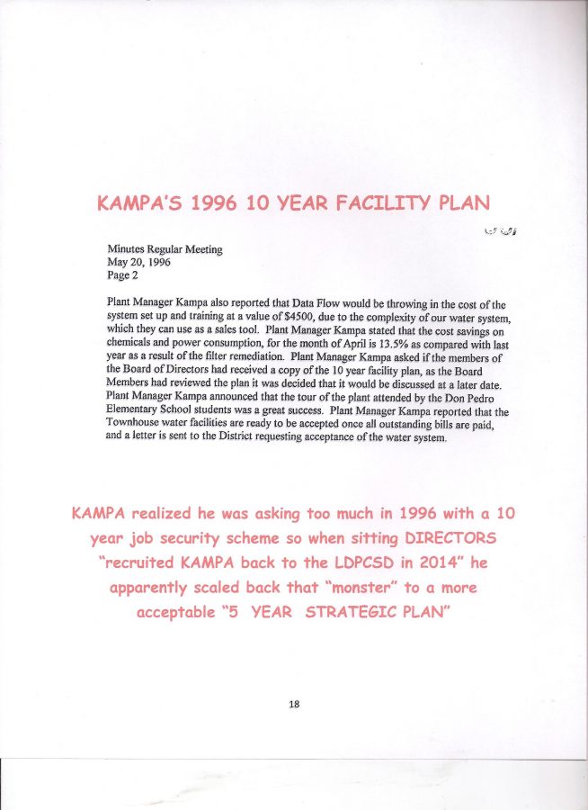
WHY NOT A HUNDRED, SEVERAL HUNDRED OR A THOUSAND NEW SERVICES DEPENDENT UPON GROUNDWATER SUBSTITUTION PAID FOR BY THOSE WHO HAVE A RIGHT TO MERCED RIVER WATER?

Is a wrong any less wrong when simply distributed among more victims?   Humm, let’s mull that over.

NO DOUBT TOUGH, BUT THAT IS NOT THE ISSUE

Developing your own groundwater well in a drought prone area like Lake Don Pedro can be a risky and expensive proposition in this geologic fractured rock and historically drought prone area.   Not like the valley where there are (were?) vast underground aquifers where users could drill wells as easy as punching a stick straw in a juice bag or carton when thirsty.  Yup, that’s all now changed and State regulations reflect the seriousness of water shortages, over drafting, land subsidence, lack of conservation, etc.

Still, quite unfortunate that it can cost a property owner a great deal to obtain sufficient quality water for development, but that’s another variable, what sort of land development requires the water?  A single family residential structure with typical associated outbuildings would require far less potable water than a several hundred parcel subdivision.  You don’t need to be an engineer to comprehend that little piece of reality.

MOST EVERYONE UP HERE SACRIFICED SOMETHING

Generally, we all must sacrifice something in order to reside (or hope to reside) in this beautiful, but often harsh, western Sierra Nevada foothill area.  Obviously traditional shopping is made a bit more inconvenient and the variety of products and services is limited, little things like that, however, there is another way many residents were able to develop up here which was “PAID FOR” in a different MORE SUBTLE, but very effective way.

STOP!  YOU CAN’T DO THAT ON YOUR PROPERTY!      

Property owners in the LDPOA residential subdivision sacrificed what many might consider “FREEDOM” in order to purchase and develop their property due to Community Interest Development CC&Rs (Covenants, Codes, and Restrictions) and the  DAVIS STIRLING COMMON INTEREST DEVELOPMENT ACT  contained in the California Civil Code starting with section 4000).   Without delving too deep into the pros and cons of CIDs, CC&Rs, Davis Stirling, and that whole concept of another layer of government to contend with,  etc. suffice it to say they are TYPICALLY FAR MORE RESTRICTIVE THAN COUNTY REGULATIONS WHEN IT COMES TO DEVELOPING YOUR PROPERTY.

One of the standard restrictions is that no property within the residential unit can again be subdivided – such as an owner dividing his 1 acre lot into two ½ acre parcels or four 1/4 acre lots.  Rules prohibit certain “cottage industries”, size and placement of the residence, even the species and number of animals permitted, some developments even regulate building colors, themes, and how much work an owner can perform on common areas.  It all depends upon your community development CC&Rs and the enforcement policies of your association.

Here in Lake Don Pedro “most” property owners cannot develop their own groundwater wells and MUST BE CUSTOMERS OF THE LDPCSD.  NO CHOICE.  Want water?  Then it must be provided by the LDPCSD according to their rules and regulations.   Yup, not like propane service where if you are dissatisfied with the price or service you can purchase elsewhere.

Weird huh?  LDP subdivision property owners MUST OBEY CSD rules and regulations to obtain water yet the CSD violates their own operating regulations while obtaining the water they serve anywhere they want!

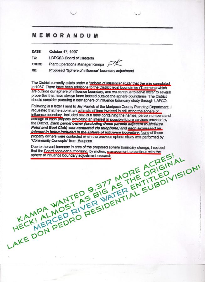
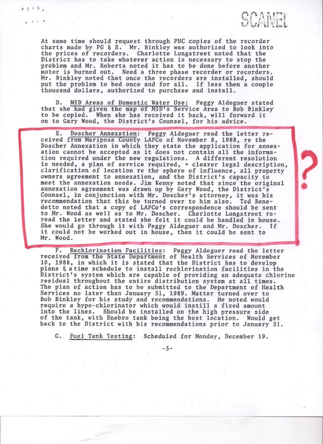
KAMPA & KOMPANY REFUSE TO PRODUCE MAPS

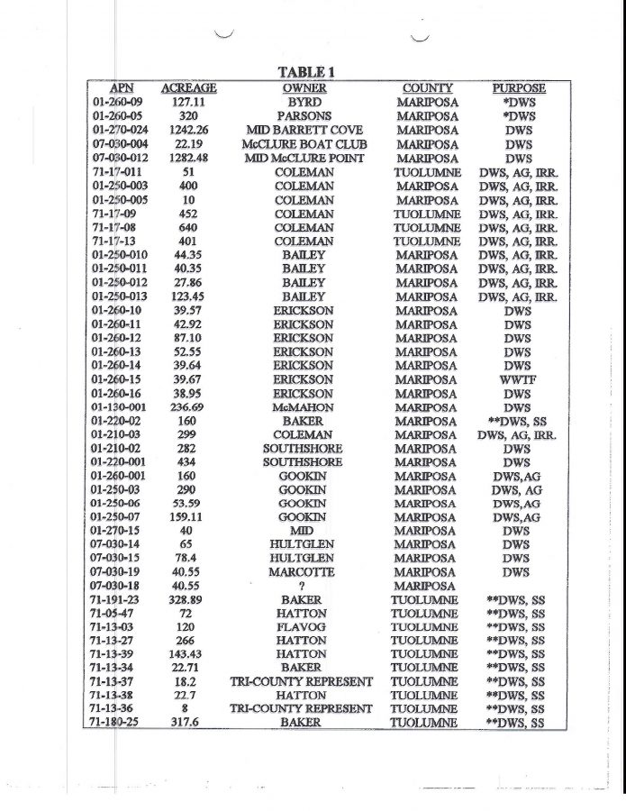
(Please recall “KAMPA & KOMPANY” is a shorthand reference to PETE KAMPA and all those who support the effort to transform our surface water treatment plant into a Groundwater Substitution facility – whose “alternate source of water” was specifically developed with public funds – in order to provide special benefit water services to third party land developers whose properties LIE outside the permitted place of use for MERCED RIVER WATER under license 11395 held by the MERCED IRRIGATION DISTRICT –  under which the LDPCSD has pumped water from Lake McClure since its formation in 1980 – while the 99% of legally entitled MERCED RIVER WATER users in the LDP subdivision have been forced to pay for this deception with rates and fees they have contributed to the LDPCSD since 1980 while those who require this GROUNDWATER SUBSTITUTION have not paid their FAIR SHARE OF AVAILIBILITY  <gasp>    lol)

ANYWAY….KAMPA & KOMPANY have for several months intentionally and repeatedly ignored and avoided TWO PRIMARY OPERATIONAL REGULATIONS OF THE LDPCSD which can be clearly illustrated on legitimate official maps:

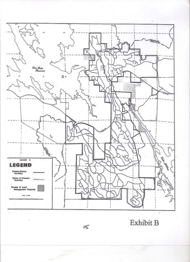
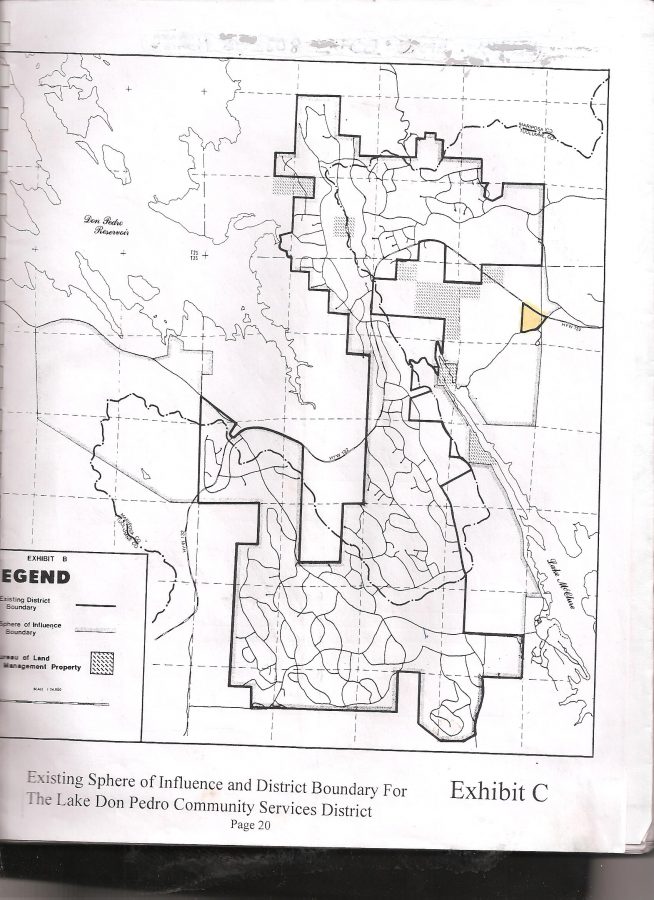
THE MERCED IRRIGATION DISTRICT PLACE OF USE MAP (MIDPOU)     (GREEN LIKE $$$)

Based on MERCED RIVER WATER restrictions in License 11395 which MID holds. Strange how a GROUNDWATER SUBSTITUTION PROGRAM (to replace Merced River Water that wrongfully leaves the MIDPOU) can legally change not only WHERE the water can be used, but HOW it is used also.  Apparently L11395 does not entertain/permit COMMERCIAL CATTLE RANCHING with treated water clearly intended for domestic consumption in the LDP subdivision, yet GROUNDWATER REPLACEMENT can be used for anything, including resale under different circumstances than what L11395 permits.

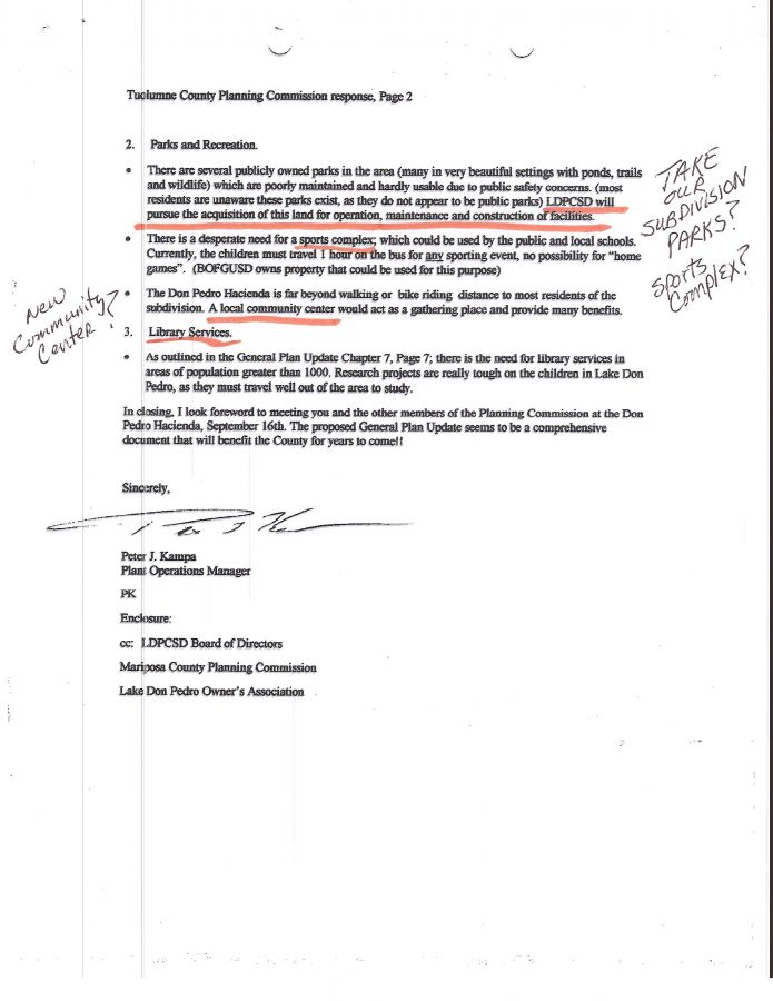
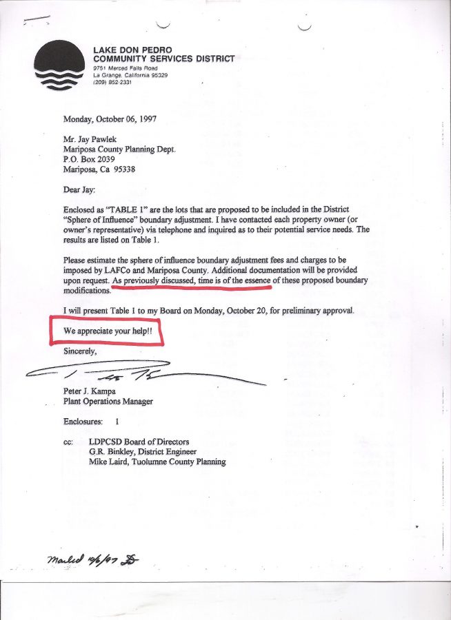
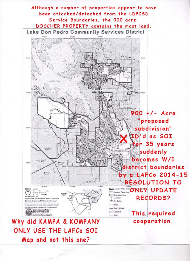
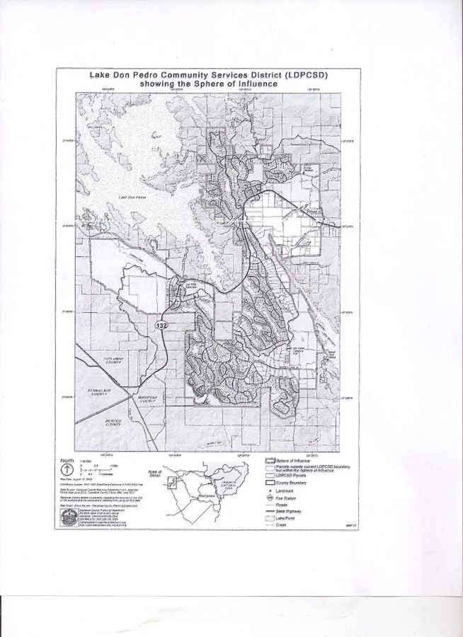
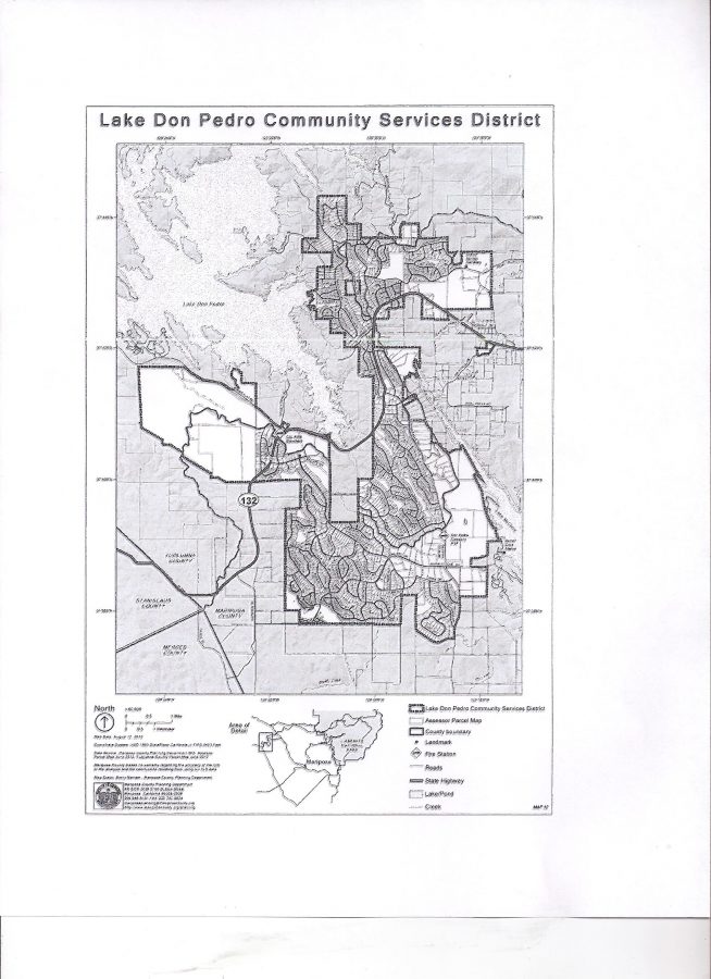
THE LAFCo WATER SERVICE BOUNDARIES MAP      (GREEN LIKE $$$)

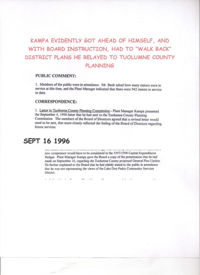
Kampa has repeatedly stated the LDPCSD Service Boundaries were created by LAFCo when LDPCSD was established in 1980 and have not changed since.

Really?

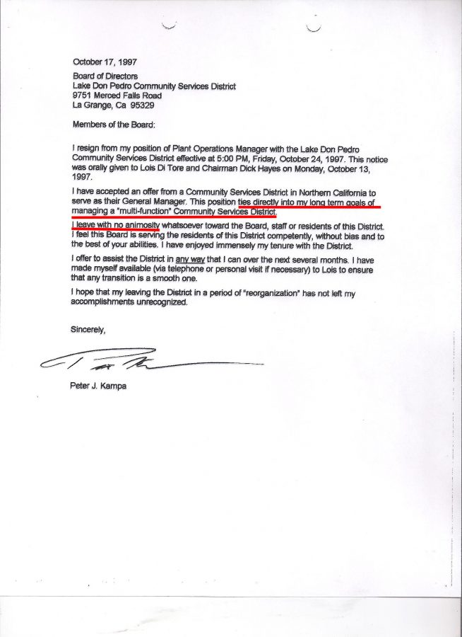
Surely as PRESIDENT & CEO OF KAMPA COMMUNITY SOLUTIONS llc (A HIGHLY PAID PROFESSIONAL MANAGEMENT COMPANY FOR SPECIAL DISTRICTS AND AGENCIES) and being an instructor to water agency employees, IGMs, GMs, and politicians within the STATE WATER INDUSTRY – AND HAVING A FEW YEARS PRIOR EXPERIENCE WITH OUR LDPCSD –  GOOD ‘OL PETE WOULD HAVE THE UP TO DATE INFORMATION. 

RIGHT?

WRONG!

Why would PETE KAMPA use that old “EXHIBIT B” map which illustrates both SOI and Service Boundaries on the same map to support his presentation?  (Which, incidentally, was incorrect anyway because the 2,010 acres of the approved South Shore Project were not included as IN THE DISTRICT BOUNDARIES!)

This is not a matter of ACCIDENTALLY using an antiquated map, but rather, ONCE AGAIN KAMPA & KOMPANY HAVE GONE TO CONSIDERABLE EFFORT TO INTENTIONALLY CONCEAL AND OBSTRUCT WHAT THE “LDPCSD BOUNDARY EXPANSIONISTS” HAVE BEEN DOING BEHIND THE SCENES SINCE EVEN BEFORE THIS DISTRICT WAS FORMED IN 1980 BY COUNTY LAFCos ——

AND THAT IS,.,.,

CONTINUING THE EFFORTS TO FURTHER EXPAND DISTRICT BOUNDARIES WITH PROPERTIES OUTSIDE THE MERCED IRRIGATION DISTRICT PLACE OF USE  FOR MERCED RIVER WATER WHICH PLACES A FURTHER FINANCIAL BURDEN ON THE ENTITLED USERS OF MERCED RIVER WATER IN THE LDP SUBDIVISION DUE TO THE NECESSARY GROUNDWATER SUBSTITUTION PROGRAM KAMPA & KOMPANY CREATED WITH PUBLIC FUNDS FOR A SPECIAL BENEFIT WATER SERVICE FOR THIRD PARTY LAND DEVELOPERS FOR WHICH OUR DISTRICT HAS NO LEGAL DUTY OR MORAL OBLIGATION TO SERVE WATER AT ALL!

KAMPA obviously had access to LAFCo’s 2014-15 UPDATED MAPS

because he used the

LAFCo RES 2014-15

SOI MAP ON THE WEBSITE! (WHICH ACCOMPANIED THE BOUNDARY MAP!)

WHAT A DECEITFUL PIECE OF…. krapa!

DIRECTOR ROSS’s CATTLE RANCH IS A PERFECT EXAMPLE OF FORESEEABLE CONSEQUENCES WHEN ALLOWING LARGE PARCELS INTO OFFICIAL BOUNDARIES THAT ARE NOT PERMITTED TO RECEIVE MERCED RIVER WATER UNDER L11395.

OK, it certainly appears as though the SUSPICIOUS SURVEY will end up producing a map with areas far outside the MIDPOU – well at least in one area around GRANITE SPRINGS WHERE ROSS DEVELOPED HIS COMMERCIAL CATTLE RANCH that was originally part of the STURTEVANT RANCH.

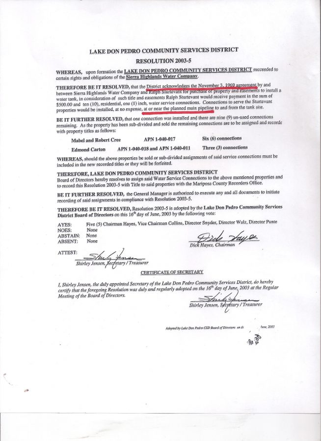
OK, we know that story based on “surviving documents of the LDPCSD AND THOSE PRODUCED BY THE STURTEVANT RANCH”.

In the late 1960s Boise Cascade engineers while constructing the [MERCED RIVER WATER ENTITLED] LDP residential subdivision in that area, realized they required another water tank and contracted a deal for a tank site and easement in exchange for some cash and 10 water meters to be used in the future.  (The individual brokering that water meter deal with STURTEVANT back in the 1960s was a shareholder in Sierra Highlands Water Company and a member of the BINKLEY FAMILY which to this day is the LDPCSD’s engineering firm.)

Did LAFCo extend the LDPCSD Water service boundary there so as to include the STURTEVANT RANCH PROPERTY because of the water tank location agreement?

OR Did they PERHAPS expand that service area for another reason AS WELL?

BUT IF because of the agreement, is there any mention of this in LAFCo documents during the LDPCSD Formation?

Why would the issue of HOW MERCED RIVER WATER WOULD BE SERVED TO THE ENTITLED SUBDIVISION, become an issue of WHERE ELSE MERCED RIVER WATER COULD BE SERVED WITHIN THE DISTRICT?

BACK TO FORESEEABLE CONSEQUENCES

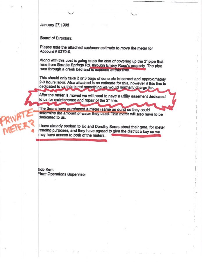
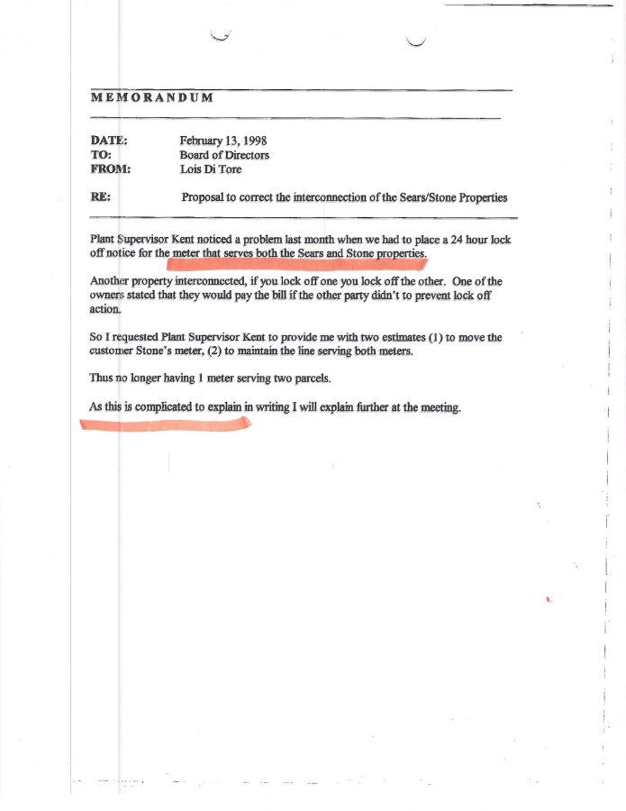
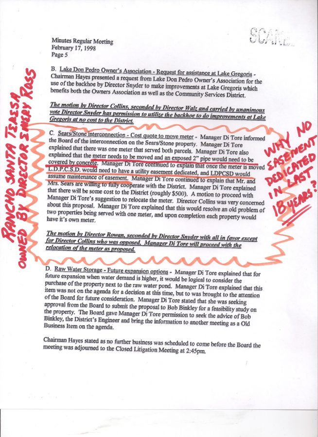
So Emery Ross wants to purchase property from the STURTEVANT RANCH yet is SPECIFICALLY ADVISED he had NO RIGHT to a water meter.

ROSS purchases the property never-the-less and is subsequently denied water by the LDPCSD multiple times.

ROSS had connections within the LDPCSD and somehow obtains a STURTEVANT WATER METER; has a fictitious water service approval date placed in district records; starts a commercial cattle ranching business with treated water intended for domestic residential consumption in the subdivision across the street; and begins authoring a bi-weekly column in the only local newspaper owned by a friend.  His column was called Ranching Don Pedro.

Nine years later a Sturtevant Ranch member attending an LDPCSD Board meeting sees some paperwork with Emery’s name on it identified as having a STURTEVANT WATER METER and discovers the MISAPPROPRIATION OF SEVERAL WATER METERS BELONGING TO THE STURTEVANT RANCH.

Naturally the Sturtevant Ranch demands correction.

Big surprise, LDPCSD records could not initially be found, but the issue was eventually resolved with the STURTEVANT RANCH meters replaced in their account.

Ross and the several other OUTSIDE MIDPOU property owners were allowed to keep their wrongfully acquired water service and the pre-dated service dates indicating they were approved under BOISE CASCADE.

Think of the AVAILABILITY FEES THAT WERE NEVER PAID IN RESTITUTION TO THE DISTRICT FOR THESE “LATE ON THE SCENE PROPERTIES” NOW RECEIVING WATER.

LDPCSD AVAILABILITY FEES:  (BASED ON LDPOA SUBDIVISION LOTS WITH AN AVERAGE SIZE OF 2 ACRES  +/- .   $60 an acre, maximum 3 acres for $180/year.   So applying the same formula for much larger parcels OUTSIDE THE MERCED RIVER WATER ENTITLED SUBDIVISION, dividing by the maximum of 3 acres (@ $180) would be reasonable.

SO:

EXAMPLES:  100 ACRES/3 ACRES = 33.33 ACRES x $180 = $5,999.40 A YEAR [1993-1980 = 13 YEARS X $5,999.40 = $77,992.20 IN AVAILABILITY FEES THAT WERE NOT PAID. (GEE, ALL LDPOA PROPERTY OWNERS THAT ARE MANDATORY CUSTOMERS OF THE LDPCSD HAVE PAID $60/AC  UP TO $180/3 AC SINCE THE DISTRICT STARTED CHARGING FEES!)

900 ACRES/3 = 300 ACRES X $180 = $54,000/YEAR   [1993-1980 = 13 YEARS X $54,000 = $702,000]

IF THE ABOVE SUCH EXAMPLES HAD PAID THAT KIND OF MONEY THROUGH THE YEARS TO “BUY IN” IT WOULD MAKE A BETTER CASE FOR INCLUSION INTO THE DISTRICT, BUT THEY DID NOT.  BESIDES, REGARDLESS OF THE LOST REVENUE IN PROPERTY TAX AVAILABILITY WE WERE STILL PILING ON MORE LIABILITY FOR A GROUNDWATER SUBSTITUTION PROGRAM.  FURTHER SERVICE OUTSIDE THE MIDPOU BOUNDARY DOES NOT MAKE MUCH SENSE – UNLESS YOU ARE THE ONE RECEIVING THAT SPECIAL INTEREST BENEFIT..

CONSIDER THIS:   SINCE KAMPA CONTENDS THE ROSS RANCH (and other large holding of land) ARE WITHIN DISTRICT BOUNDARIES (not MIDPOU for MERCED RIVER WATER SERVICE REMEMBER)………….

theoretically such properties with a co-operative EXPANSIONIST MOTIVATED MANAGEMENT TEAM like KAMPA & KOMPANY could easily develop into a hundred, several hundred or thousands of new home sites (OR CATTLE RANCHES, CAR/TRUCK WASHES, WATER PARKS, ETC.!

ALL OUTSIDE THE PLACE OF USE FOR MERCED RIVER WATER!

NOW HERE IS THE KICKER…..

Thousands of homes buil (OR WHATEVER)  OUTSIDE THE PLACE OF USE FOR MERCED RIVER WATER, whose extremely expensive GROUNDWATER SUBSTITUTION PROGRAM would be FINANCIALLY SUPPORTED by the property owners of the LAKE DON PEDRO OWNERS ASSOCIATION subdivision WHO HAPPEN TO BE THE ONLY LEGALLY ENTITLED MERCED RIVER WATER USERS IN THE DISTRICT!

NOT ONLY THAT…..those properties are also essentially insured against failure because if the ground well fails – it’s already been deeded to the LDPCSD SO WE HAVE TO REPLACE THAT EXPENSIVE PIECE OF SPECIAL BENEFIT!

WHAT A FRACKEN SCAM THAT WAS/IS APPARENTLY

SUPPORTED BY MARIPOSA COUNTY PLANNING AND LAFCo !!!

I need to get to “other work”.

My best to you and yours, Lew

Oh yeah:

Is a wrong any less wrong when simply distributed among more victims?

Recall this when your LDPCSD water bill is doubled or tripled in order to

pay for all these special benefits for properties NOT ENTITLED TO MERCED RIVER WATER!

TRULY DISGUSTING.

OH YEAH…..,.

VOTE NO ON ANY SUBSEQUENT

LDPCSD PROP 218 THAT SUPPORTS THIS

KAMPA KRAPA FRAUD!


Categories: Uncategorized.