


Judging by the 25 years of traveling Merced Falls Road from the Lake Don Pedro subdivision to the city of Merced and experiencing the traffic first hand, I can comfortably state that many of us utilize this “short cut” rather than traveling HWY 132 into La Grange and then HWY 59 south to Snelling on our way to Merced and else where in the valley. [I often use both routes (Merced Falls and HWY 59 to Snelling) for a bit of variety on routine journeys – one going downhill, the other returning uphill, just to make that literal “round trip” to Merced and back.]
Did you know our familiar winding Merced Falls Road could have been dramatically changed by a MERCED IRRIGATION DISTRICT water holding proposal documented in Bulletin Number 131, MARIPOSA AREA INVESTIGATION by the Resources Agency Department of Water Resources in November 1965? Check out the below map found while researching the water issues of this area:
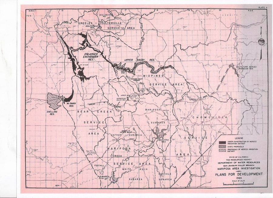
The unincorporated area of MERCED FALLS (middle-left side of map and west of McSwain Reservoir [currently known as Lake McSwain], would have been under the proposed SNELLING RESERVOIR! Much like the town of Bagby on HWY 49 between Coulterville and Mariposa that was submerged due to construction of the New Exchequer Dam, Merced Falls would have been relegated to similar “underwater status” as water backed up from the (proposed) construction of the Snelling dam. Notice also the massive holding of water on the Merced River east of Bagby along with the many other water holding/diversion proposals scattered about the area. Absolutely fascinating with all the engineering and planning involved with such major projects. This doesn’t have anything to do with current LDPCSD issues but I thought it interesting enough to share.
Now on to burn day preparation! Rain is on the way!
My best to you and yours, Lew
